Date of Incident
Publication Date
Methodologies
Forums
Exhibitions
- Cloud Studies at Tensta Konsthall
- Biennale Nemo
- Cloud Studies at the Whitworth
- Antibodies
- Cloud Studies at UTS Gallery
- Enter the Void
- The Image Looks Back at PHOTO 2020
- Forensic Architecture: True to Scale
- Violence, Fast and Slow at State of Concept Athens
- Forensic Justice
- Change the System (Extension)
- Counter Investigations
- Change the System
- Forensic Architecture: Hacia una Estética Investigativa
- The Other Architect
- Situation #82: Bomb Cloud Atlas
- Forensic Architecture: Towards an Investigative Aesthetics
- The Urban-Data Complex
- Burden of Proof
- Obliterated Families Project
- Constellation.s
- Forensic Architecture at Venice Architecture Biennale 2016
- The Next Big Thing Is Not A Thing
- Artefact 2016 | Up in the Air
- The Urban-Data Complex at Bi-City Biennale of Urbanism/Architecture 2015
- The Other Architect
- Kent Klich: Black Friday
The kidnapping of an Israeli soldier by Hamas during the 2014 Gaza conflict resulted in four days of bombardment, in which over two thousand homes were destroyed.
Lt. Hadar Goldin’s abduction led Israeli military leadership to implement what was known as the Hannibal Directive, a classified military order that is understood to permit Israeli soldiers, in the event of a fellow soldier’s capture by enemy forces, to target the captive and his captors with maximum available firepower, regardless of the risk to the captive soldier’s life. The bombardment of Rafah on 1 August was intended to destroy the tunnels under the city into which the soldier had been taken.
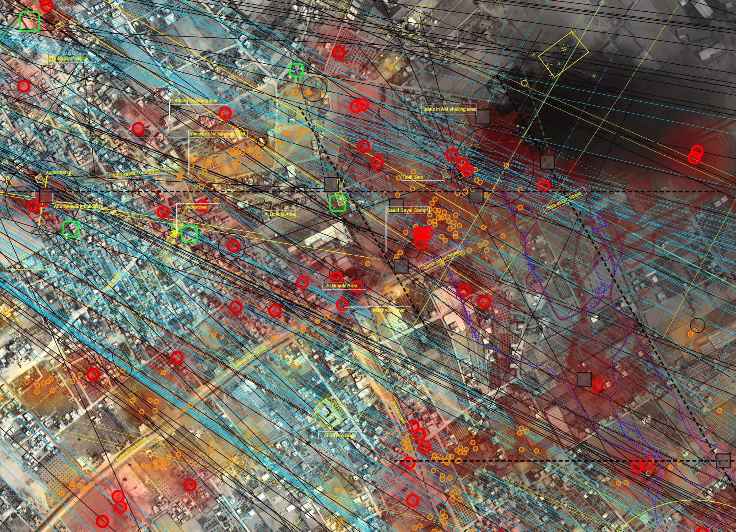
Amnesty International and Forensic Architecture (FA) were denied entry into the Gaza strip, and as such our investigation into the bombardment of Rafah relied on thousands of images and videos shared online, or sent directly to FA, by citizens and journalists.
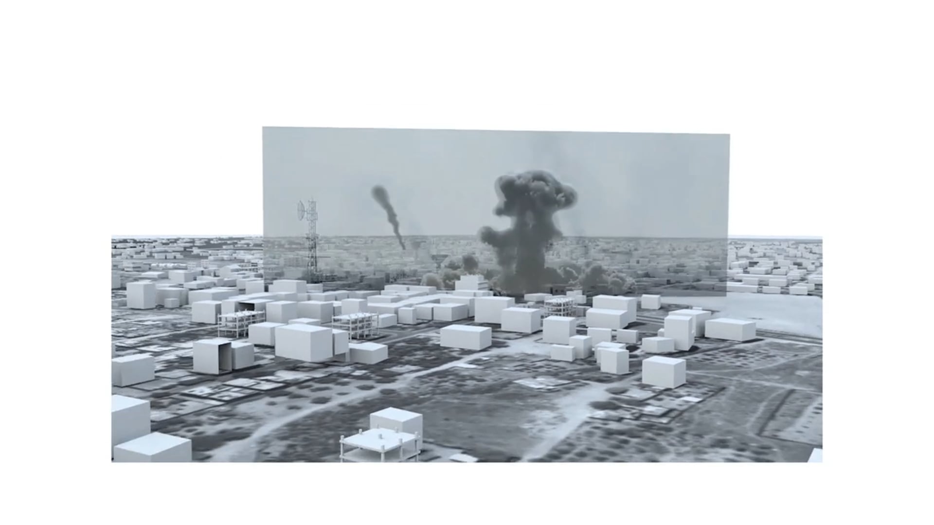
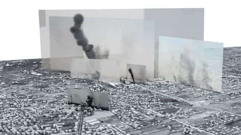
Through a process of locating cameras and incidents within a digital model, and subsequent analysis of satellite and ground-level images, smoke clouds, shadows and impact craters, we mapped hundreds of air-to-surface and artillery strikes that hit the city of Rafah on 1 August.
Our research supported the following conclusions by Amnesty International in their report ‘Black Friday: Carnage in Rafah’:
There is overwhelming evidence that Israeli forces committed disproportionate, or otherwise indiscriminate, attacks which killed scores of civilians in their homes, on the streets and in vehicles and injured many more. This includes repeatedly firing artillery and other imprecise explosive weapons in densely populated civilian areas during the attacks on Rafah between 1 and 4 August. In some cases, there are indications that they directly fired at and killed civilians, including people fleeing.
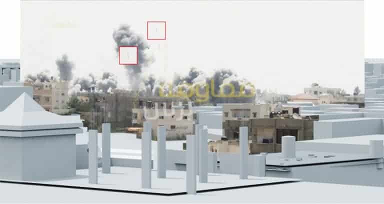
One of the videos we examined included two still frames that captured bombs mid-fall, fractions of a second before impact.
By locating the images within the 3D model, we were able to identify the bombs as one ton bombs. Amnesty International’s subsequent report identified the use of this munition as a war crime.


Methodology
Methodology
Because social media tends to strip images of their original metadata, including time and location, FA had to piece together this information by studying elements within the image, such as shadows and the shape of bomb clouds, to locate each image in time and space and compose a narrative of the day.
‘Before’ and ‘after’ images were used to assess changes in site condition at attack sites under analysis. The ‘before’ satellite image served as a baseline from which any disturbance to the natural or built-up environment may be identified in the ‘after’ image.
Three satellite images were used in this project, dated 30 July, 1 August and 14 August. Each image extends westward from the Gaza-Egypt border to encompass central Rafah and was captured around 11.39am. The 1 August image, in particular, captures a moment only two and a half hours after the ceasefire collapsed, during the peak of the Israeli bombardment.