Date of Incident
Location
Publication Date
Commissioned By
Additional Funding
Collaborators
Methodologies
Forums
Exhibitions

Introduction
On 11 and 12 January 2024 the International Court of Justice (ICJ) held public hearings on the request for the indication of provisional measures submitted by South Africa in the case concerning Application of the Convention on the Prevention and Punishment of the Crime of Genocide in the Gaza Strip (South Africa v. Israel). On 11 January, South Africa presented its case and on 12 January, Israel staged its defence.
As part of its defence, the Israeli team presented visual material, including maps, videos, images, and annotated diagrams. We have sourced the elements of evidence from the recording of the Israeli legal team’s presentation at the ICJ as found on the United Nations website.
Aim of study
We reviewed the visual evidence presented by the Israeli legal team according to three categories:
- Authenticity, i.e. whether the evidence has been tampered with.
- Annotation, i.e. whether elements in the evidence have been correctly labelled or annotated.
- Interpretation, i.e. whether the claims made by the Israeli legal team were consistent with the visual evidence presented.
Method
For each of the pieces of visual evidence we examined:
- We verified the source, time, and location based on information collected from publicly available material.
- We conducted additional analysis using open-source research and satellite images sourced from Planet.
- When the Israeli team presented a video still, we located the source video and examined it in its entirety. We also investigated any claims made by Israeli government or military sources when the video in question was originally published.
- In some cases, we employed 3D modelling to reconstruct key physical sites relevant to the claims, and calculated distances, shadows, positions of figures and other elements, and trajectories of projectiles seen in the video where applicable.
- We cross-checked the available material against cartographic information about the known location of the Israeli military at the time of each incident and evacuation orders given by them.
Findings
We found eight instances where the Israeli legal team misrepresented the visual evidence they cited, through a combination of incorrect annotations and labelling, and misleading verbal descriptions. These instances are presented and explained in this report.
Our study also reveals that the Israeli legal team presented single instances of alleged Palestinian military use of civilian infrastructure as blanket justifications for the systematic and widespread attacks on civilians, shelters, schools, and hospitals.
Visual Materials / Evidence Presented
Rocket Launch Site
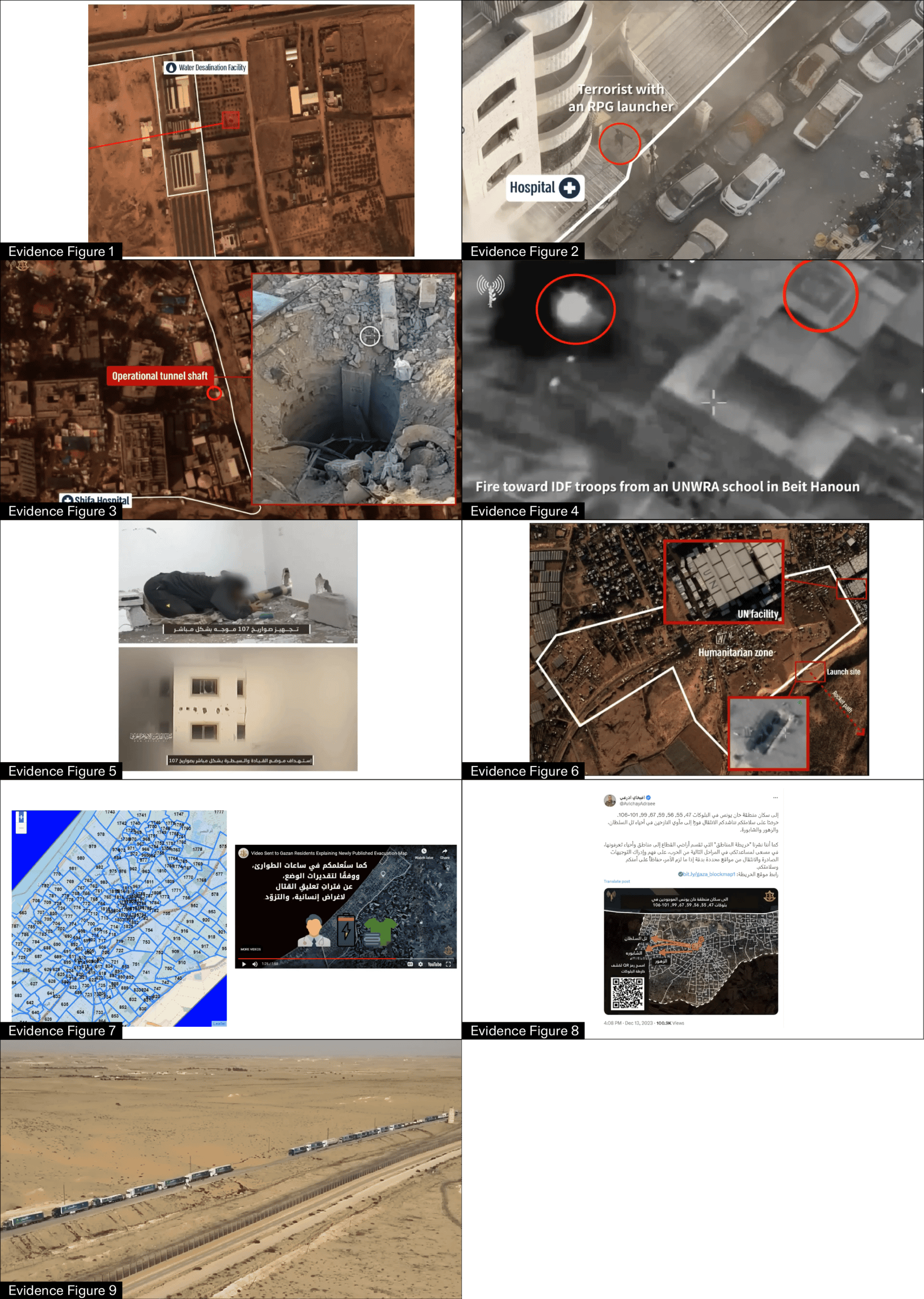
The Israeli legal team presented Evidence Figure 1 claiming it as proof of a rocket launch site close to a water desalination facility. The figure is a satellite image with a red annotation highlighting the purported launching site. The highlighted feature is more likely a crater caused by an air drop munition from an Israeli strike. When presenting this image, the Israeli legal team claimed:
‘And in the next slide you can see evidence of a rocket launched from next to Gaza’s water desalination facility.’
Analysis
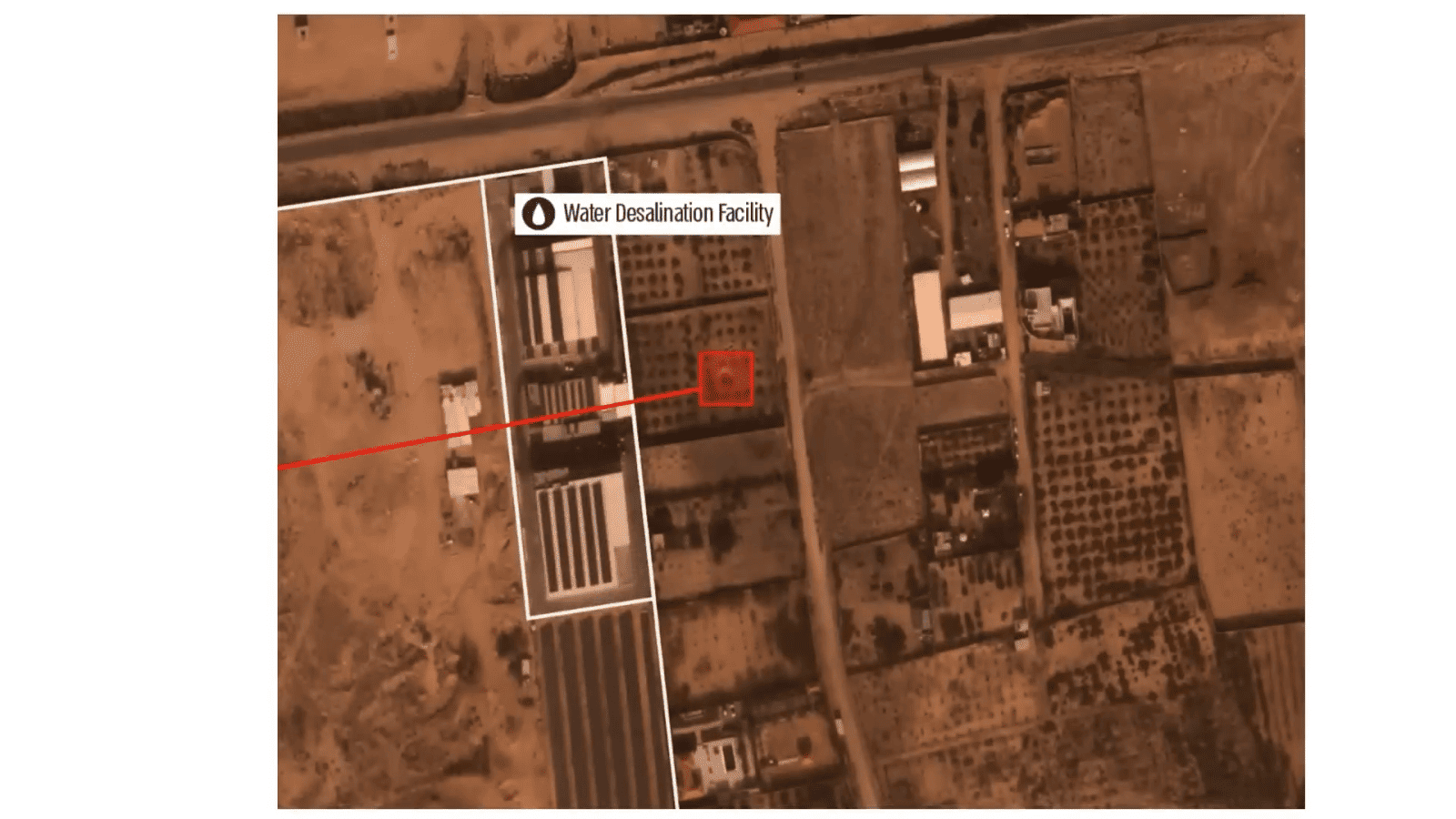
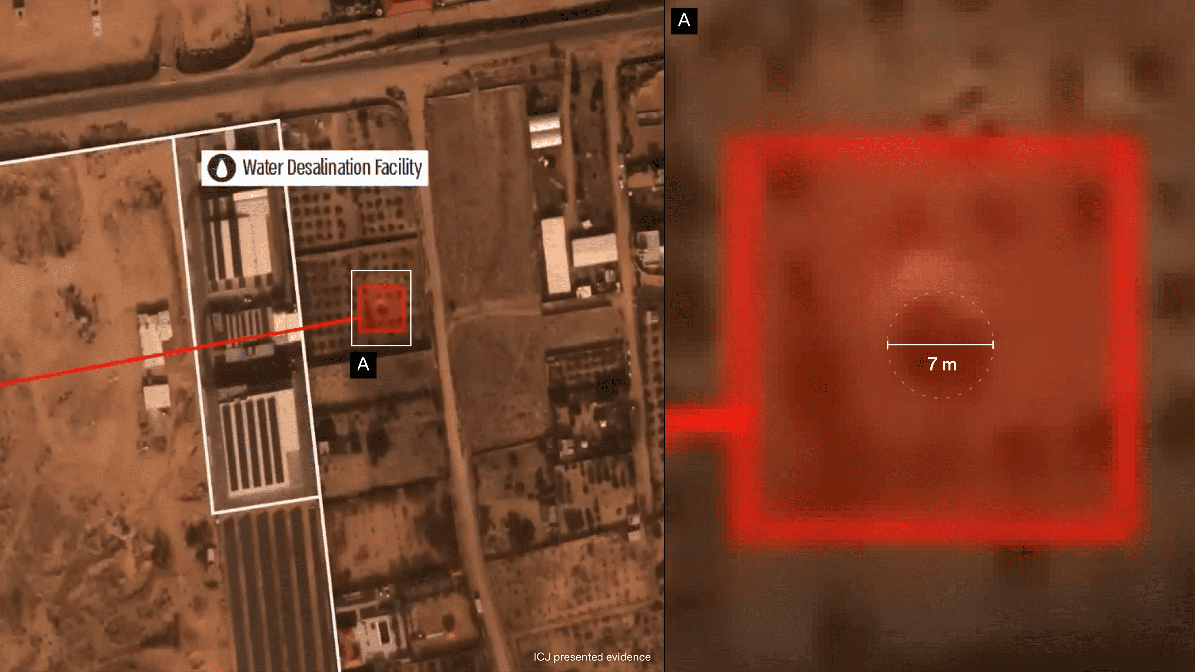
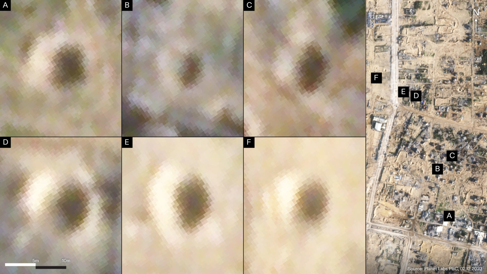
The claim of Evidence Figure 1 was first published by the Twitter account of COGAT. We have geolocated the highlighted feature at the following coordinates: 31.40524217, 34.31710552. Our analysis suggests that the highlighted ground disturbance is a crater likely caused by an Israeli bomb. We used satellite images and 3D modelling to calculate the size and depth of the highlighted feature. The crater measures approximately 7m in diameter and, according to our shadow analysis, 2m in depth. The dimensions of the crater are consistent with the impacts of a bomb between 500lb and 1000lb. We compared its dimensions and shape to those of other craters visible throughout Gaza and found them to be consistent with one another.
Assessment
We found that the Israeli legal team incorrectly labelled and annotated the image presented at the ICJ hearing, labelling a crater—a trace of Israeli-inflicted destruction—as a Palestinian rocket launch site.
Hospitals: Al-Quds Hospital
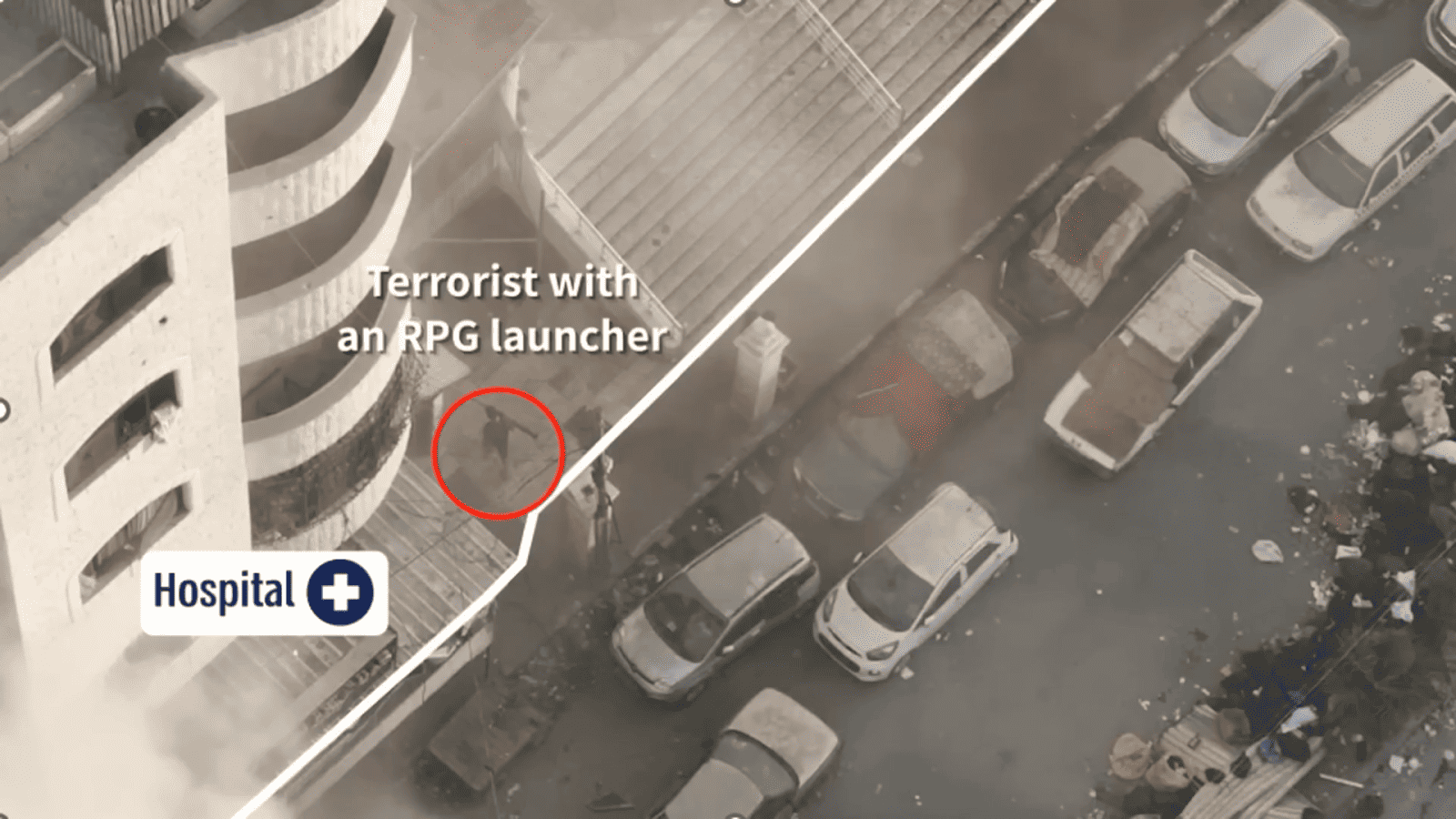
The Israeli legal team presented Evidence Figure 2 to claim that al-Quds Hospital was used for military purposes and thus the targeting of al-Quds and other hospitals was justified.
The footage from which the still image derives, likely taken by a drone, was annotated with lines and labels indicating the purported boundaries of the hospital and the location of a Palestinian fighter. When presenting this image, the Israeli legal team claimed:
‘In the slide before you, you will see a militant going into Quds Hospital with an RPG. Hamas fired at IDF forces from near, and from within, Quds Hospital.’
Analysis
The image (Evidence Figure 2) presented at the ICJ hearing was derived from a video published as part of a press release on 13 November 2023 by the Israeli military. The full video is made up of three clips showing military confrontations around the hospital.
Analysis of the image presented at the ICJ hearing
We examined the annotations of the image presented by the Israeli legal team, the claims made with it, as well as the full press release and video from which it derived.
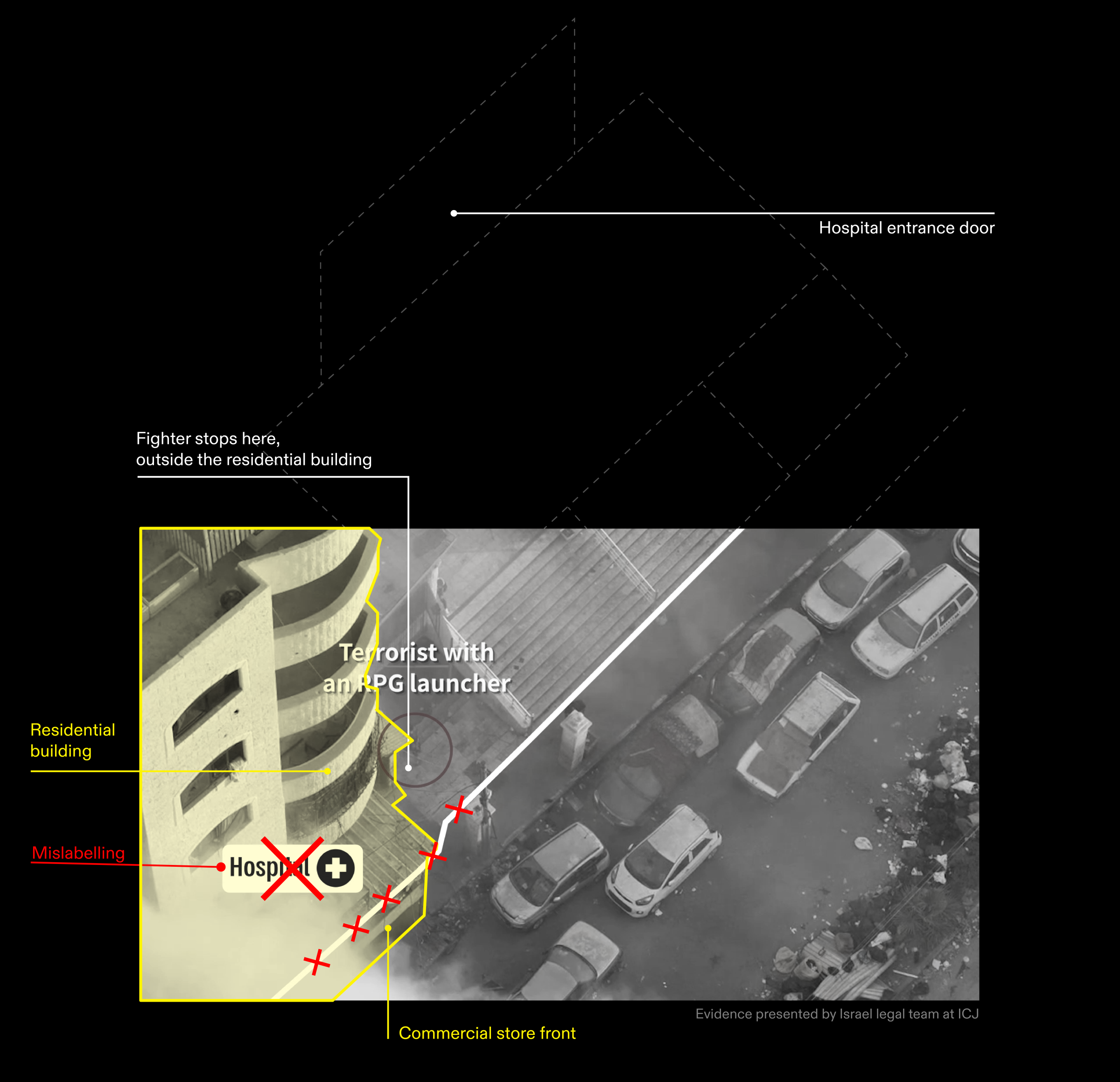
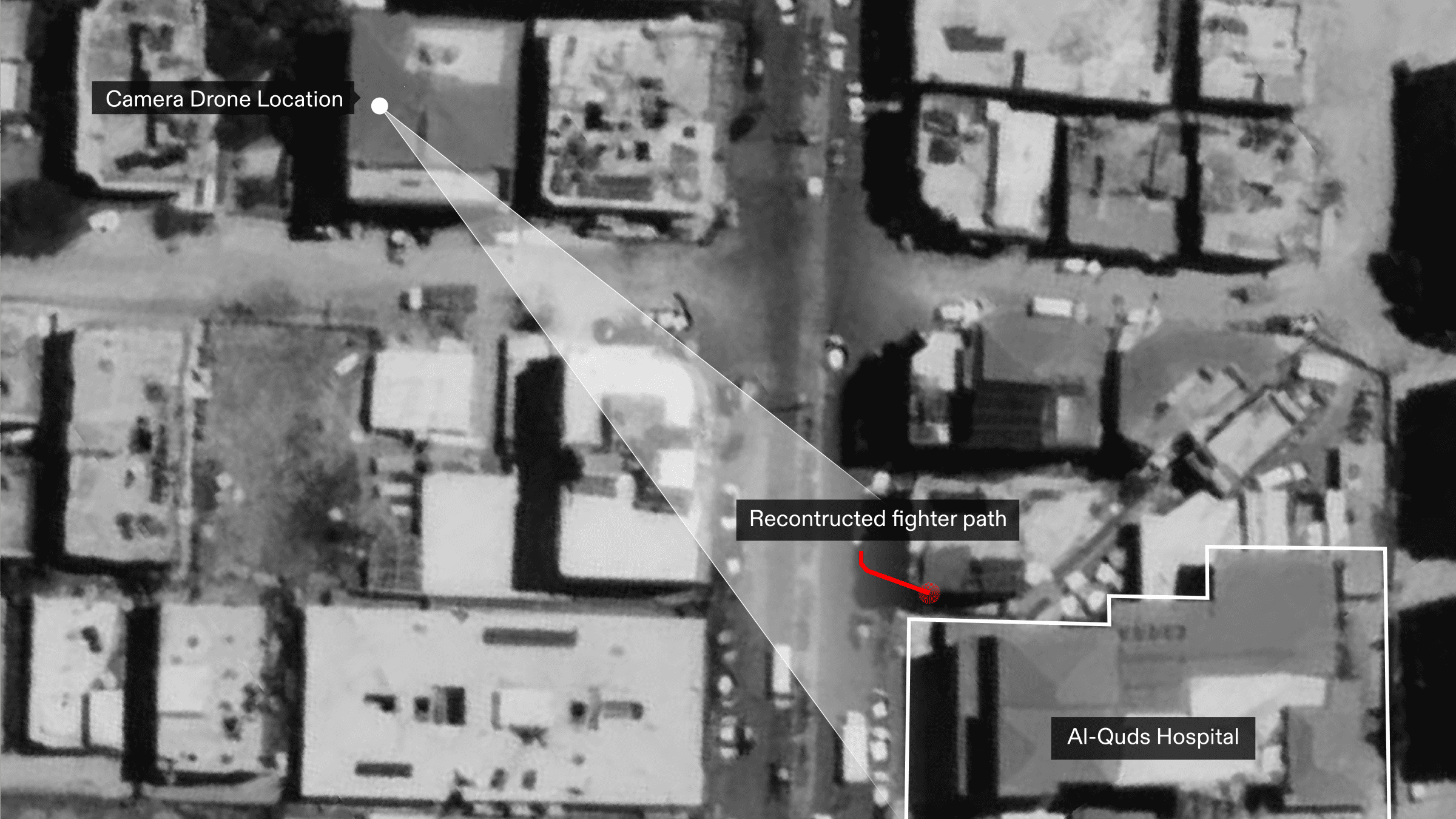
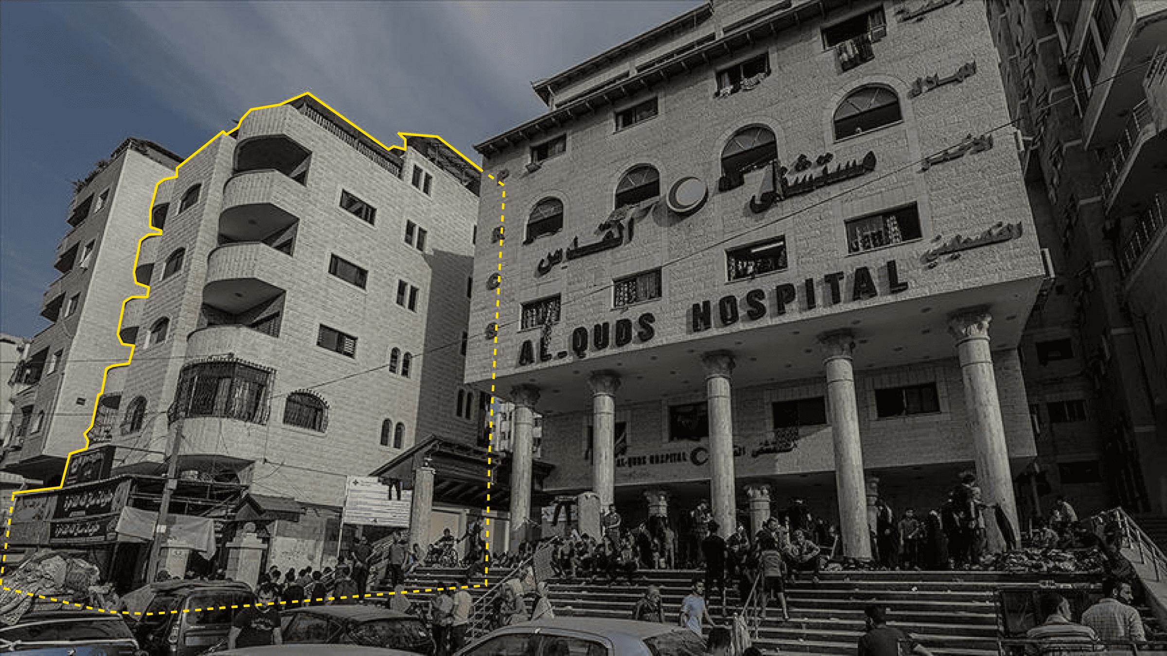
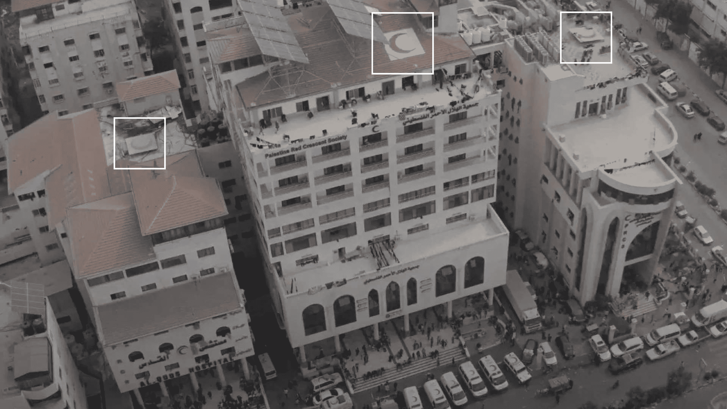
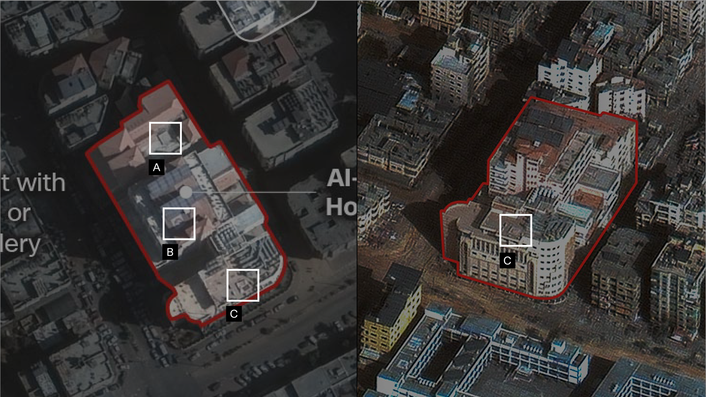
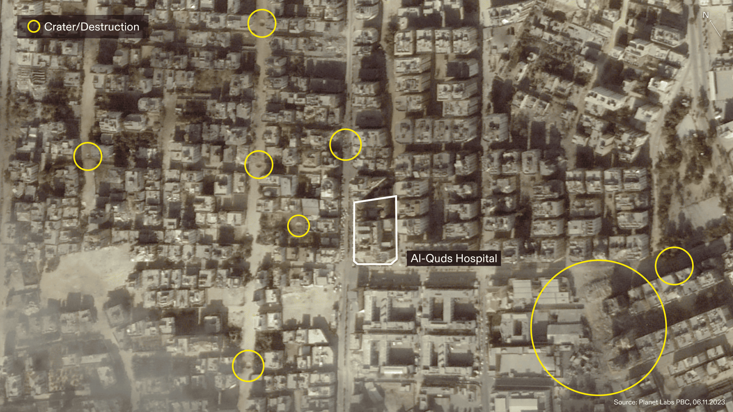
We searched for photographs of the hospital and analysed them for indications of the hospital’s boundaries. We found that the hospital is likely comprised of three main buildings, each with clear signage. Two buildings north of the hospital complex are wrongly included in the Israeli military’s annotation of the hospital boundary. One of these buildings appears in Evidence Figure 2, on the left of the image. The building appears to be a mixed use commercial and residential building. The ground floor of the building has a commercial sign for a shop selling sweets or desserts reading ‘[continues] حلويات’ (‘Desserts [continues]’ in English). The building’s upper levels and balconies indicate residential use.
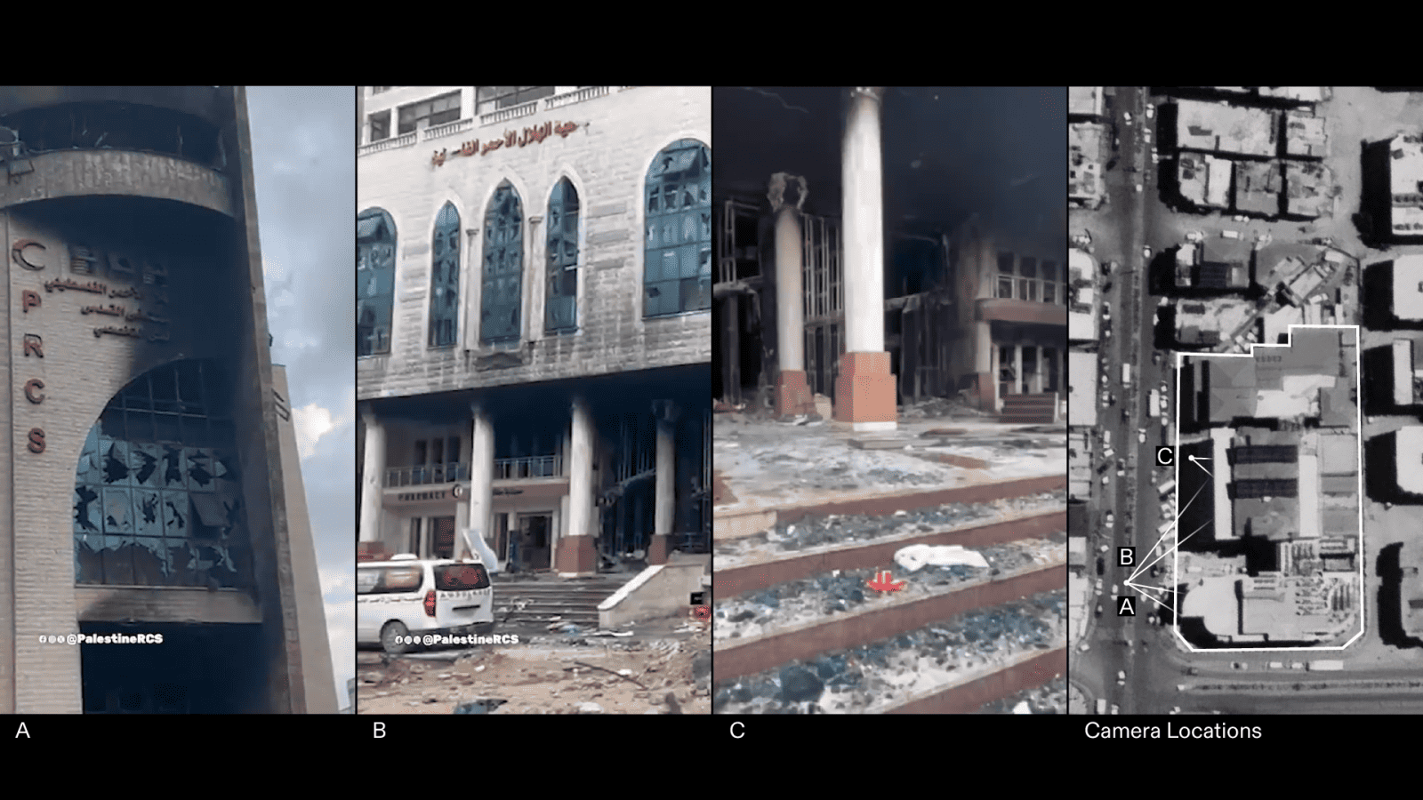
Aerial images of the hospital published by Al Jazeera and CNN reinforce our findings regarding the correct boundary of the hospital complex, as they show a prominent red crescent symbol present on each of the three hospital buildings. The red crescent symbol is absent from the two buildings included in the Israeli military diagram of the hospital boundaries.
To confirm the boundaries of the hospital, we contacted Dr Abdullatif Alhaj, the previous Director General of Hospitals in Gaza at the Palestinian Ministry of Health. He pointed us to which buildings made up the hospital and confirmed that the building to the left of the image presented by the Israeli legal team (Evidence Figure 2) does not belong to the hospital complex. We note the borders of the hospital as published by CNN are consistent with the boundaries we have found.
Figure 4 shows a still from the full video similar to Evidence Figure 2 with corrected annotations (erasure and labels).
Analysis of the full press release video
Next, we examined other elements and claims made in the 13 November 2023 press release and in the video from which Evidence Figure 2 was derived.
In the video, we do not see the Palestinian fighter, pointed to by the Israeli legal team during the ICJ hearing (Evidence Figure 2), entering the hospital at any point.
We found the other two clips within the video also incorrectly annotated the boundary of the hospital by including the two buildings to its north.

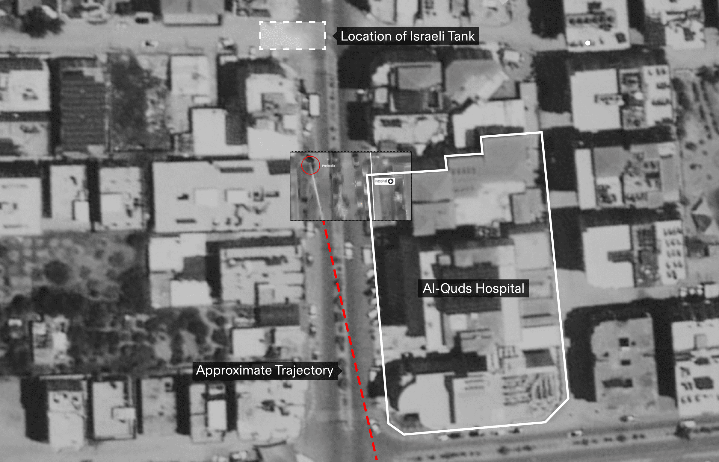
In the third clip of the video, the Israeli military claims that the projectile visible in the video, seen with a smoke trail in the drone footage released, was fired from the al-Quds hospital. The video is annotated with a caption reading ‘RPG launched at our forces from ‘Al-Quds’ Hospital’.
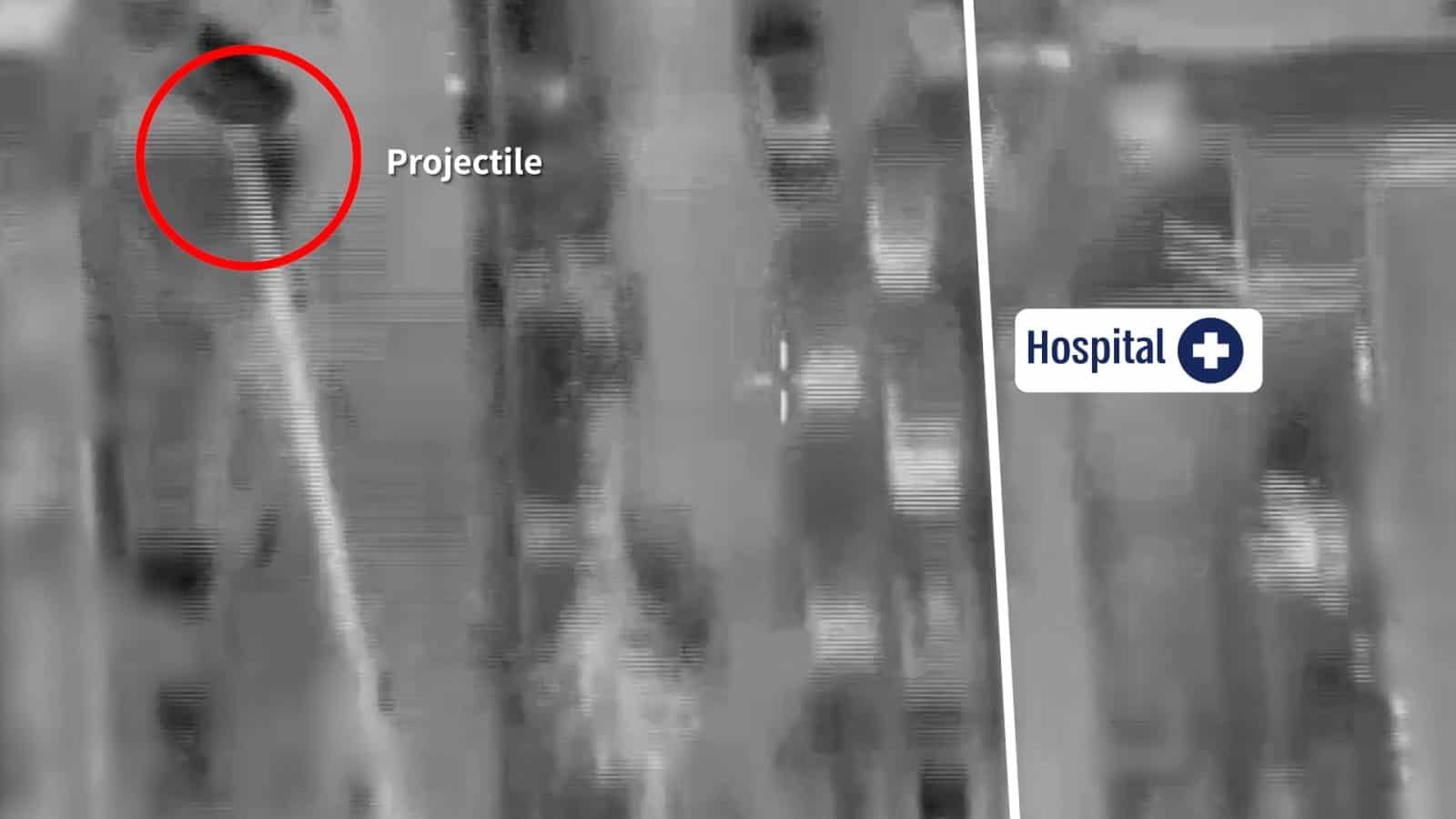
Within a 3D model of the hospital and its immediate surroundings, we ‘photo-matched’ a still from the video to reconstruct the trajectory of the projectile. Our analysis shows that the extended trajectory, highlighted in red in Figure 11, could not have originated from the hospital.
Assessment
We found that the annotation of the image presented by the Israeli legal team during the ICJ hearing was incorrect. This incorrect annotation appears throughout the 13 November press release video, where Evidence Figure 2 comes from. The incorrect annotation is used in an incorrect interpretation.
We found no evidence of the presence of Palestinian armed operations inside the hospital.
We found that the claim, made in the 13 November press release, that a projectile was fired from inside Al-Quds hospital, to be false.
Context
Al-Quds hospital was targeted by Israeli forces with a series of attacks before and after the 13 November 2023 press release in which they claim they were fired at from the hospital.
On 14 October 2023, the Israeli army first ordered the Al-Quds Hospital to be evacuated, a month before its spokesperson claimed a video of a fighter near but outside the hospital was evidence of military activity within it. On 20 October 2023, hospital director Dr Bashar Mourad received a call from the Israeli army demanding the immediate evacuation of the hospital. The justification provided was that there was an Israeli ‘military operation’ taking place in the vicinity. Dr Murad reported that at the time of the evacuation order, there were 12,000 displaced persons seeking refuge inside the hospital, in addition to patients and medical staff. Among them, 70% were women, children, and the elderly.
Between 15 October and 14 November 2023 (the day patients and medical staff were fully evacuated), the area surrounding the hospital was reportedly heavily targeted, making it nearly impossible for ambulances to reach injured people and bring them back to the hospital. On 4 November, the entrance to the emergency ward of the hospital was targeted by Israeli forces, resulting in 21 injuries according to the Palestinian Red Crescent Society (PRCS). On 10 November, the intensive care department was targeted. The Israeli military did not provide evidence to justify either attack. The hospital went out of service on 12 November and was fully evacuated on 14 November. Videos after the Israeli strikes show extensive damage inside the hospital.
On 13 November, the Palestinian Red Crescent Society (PRCS) responded to the press release: ‘The Palestine Red Crescent strongly condemns the false claims by the occupying forces about armed individuals launching projectiles from inside Al-Quds Hospital’. Our findings are consistent with this statement.
Hospitals: Al-Shifa Hospital
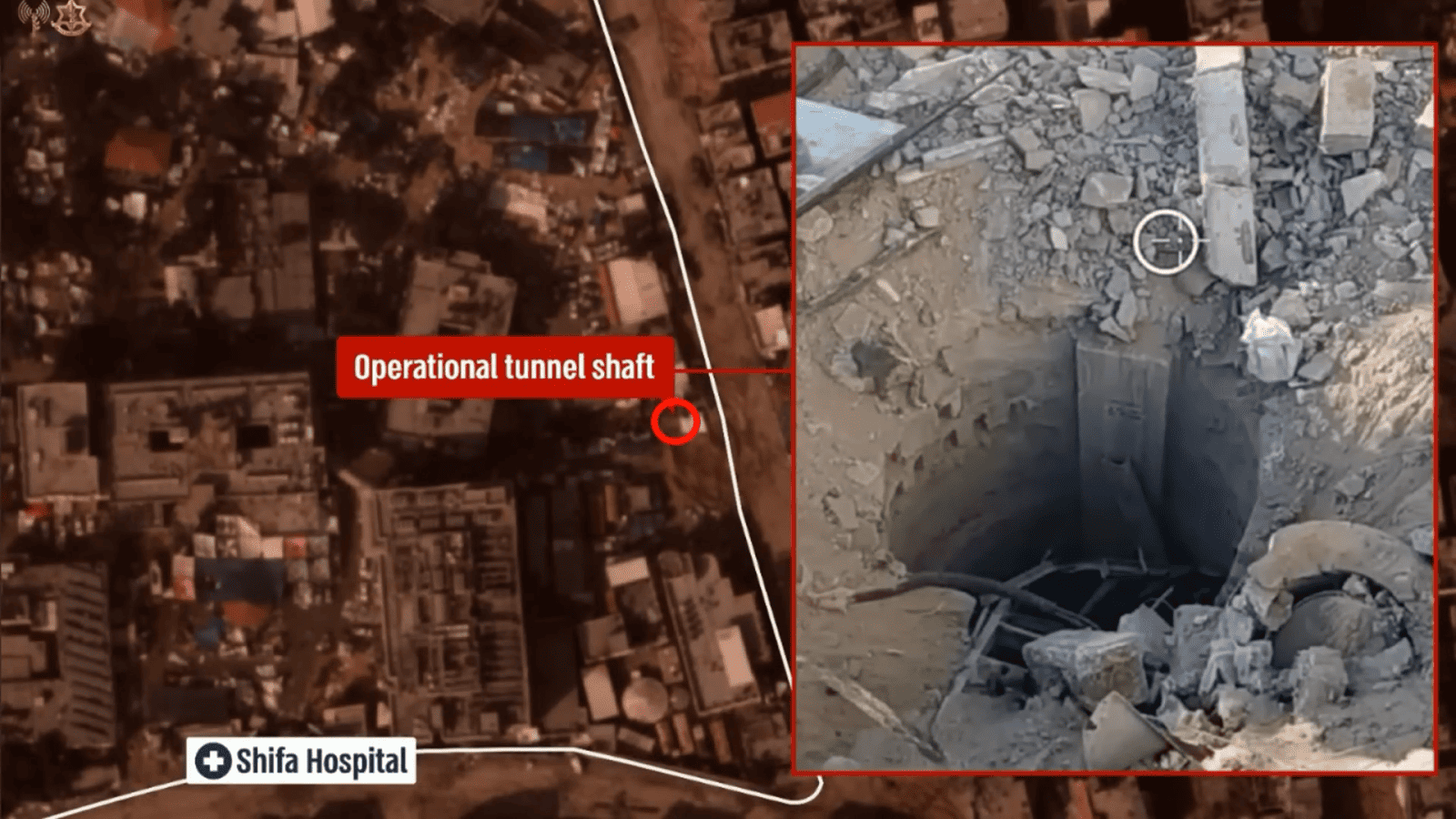
The Israeli legal team presented Evidence Figure 3 to support their argument that Al-Shifa Hospital had been a legitimate military target. The figure is a composite of a satellite image (with a circle annotation claiming to be the location of a tunnel shaft) and a drone photograph showing the tunnel shaft. While presenting this image, the Israeli legal team stated the following:
‘At Shifa hospital, Gaza’s largest [hospital], Hamas managed operations from a closed off area. Here you can see an opening to the tunnel that ran for hundreds of metres directly under the hospital.’
The Israeli legal team further claimed that:
‘Hospitals have not been bombed; rather, the IDF sends soldiers to search and dismantle military infrastructure, reducing damage and disruption. Indeed, the tunnel that sat directly under the main building in Shifa Hospital was exploded without damaging the building above. The IDF then withdrew from the hospital.’ (emphasis ours)
Analysis
Evidence Figure 3 is derived from an Israeli military press release published on 20 November 2023. We examined the image by the Israeli legal team at the ICJ hearing and the claims they made based on it regarding the length and location of the tunnel, and the Israeli military’s actions at Al-Shifa:
- Length of tunnel
The Israeli legal team claimed the tunnel ran for ‘hundreds of metres directly under the hospital’. Meanwhile, the Israeli military claims in their 20 November press release, from which Evidence Figure 3 is derived, that the tunnel is 55 metres in length. The Israeli legal team’s claim about the alleged tunnel’s length is therefore inconsistent with their own military statements. - Location of the tunnel shaft and attacks on Al-Shifa
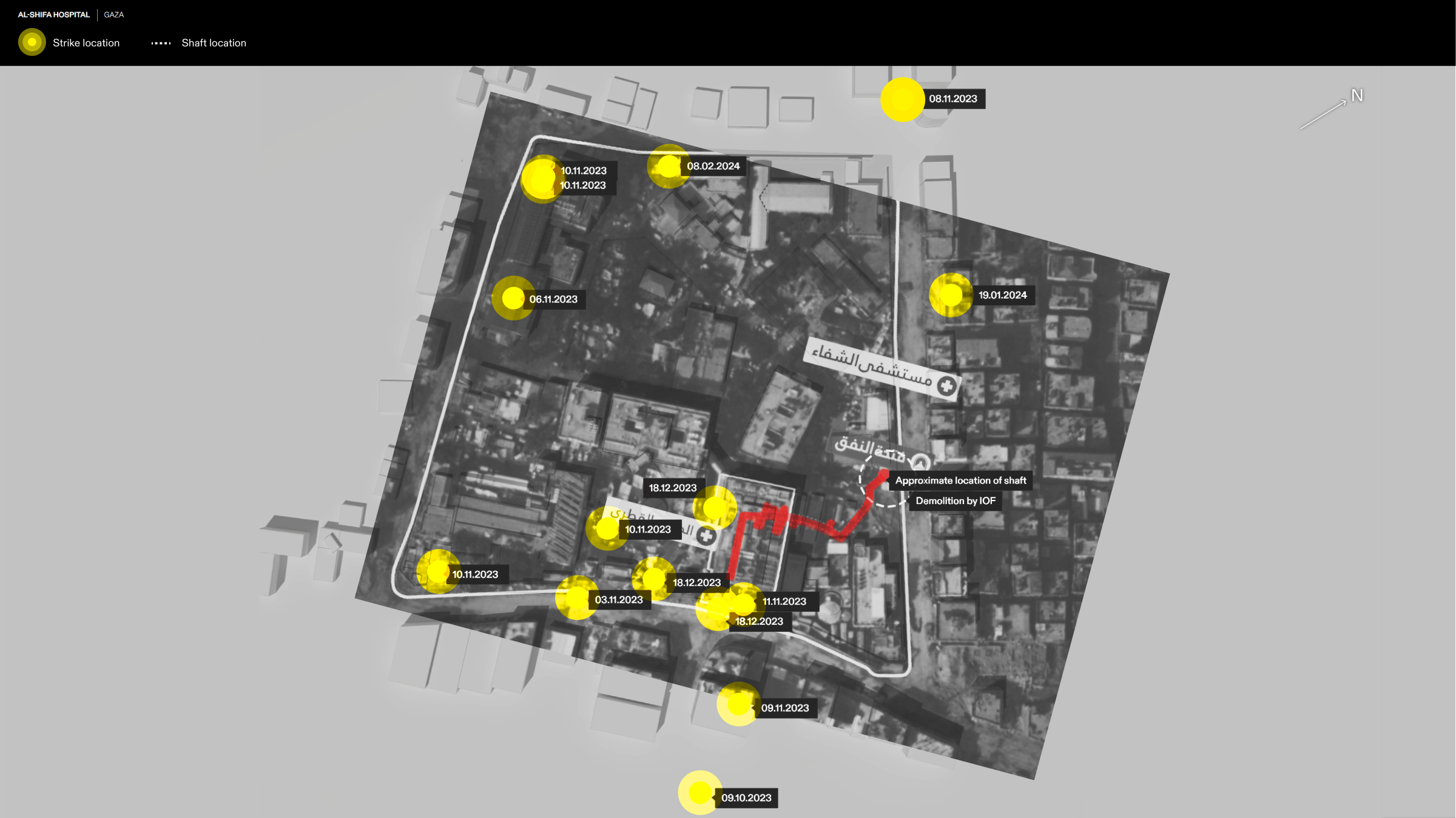
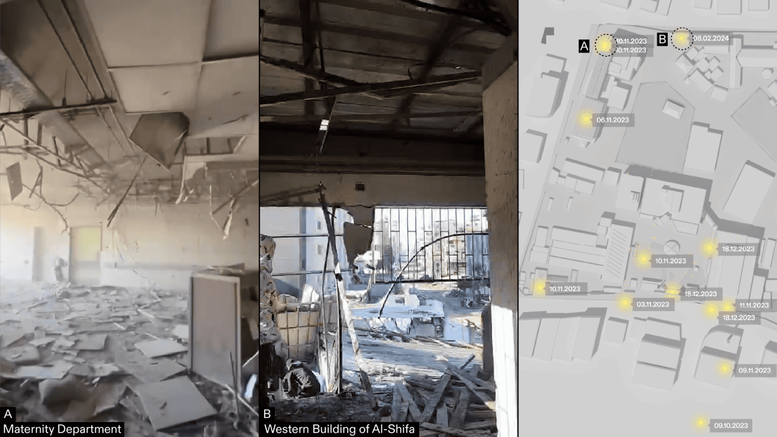
We established the location of the tunnel shaft and the footprint of the tunnel, in relation to the architecture of Shifa hospital and the timeline and location of attacks on the hospital complex. The hospital is made up of a complex of buildings within a large campus. We have found visual evidence for 11 direct strikes on Al-Shifa, with witness reports indicating that this number could be even higher. None of the areas targeted in these 11 direct strikes correspond with the location of the tunnel shaft or the sections of the hospital under which the Israeli military claimed a tunnel runs. - Bombing hospitals
Despite Israel claiming that ‘Hospitals have not been bombed’, our research documents 11 times Al-Shifa has been directly attacked by the Israeli army, starting on 3 November and as recently as 8 February. Figure 15 offers evidence for the bombing of Al-Shifa, showing the aftermath of the 10 November strike on the Maternity Department, and that of a building west of the compound, struck on 8 February.
Assessment
We found the Israeli legal team’s claim about the tunnel that ran for ‘hundreds of metres directly under the hospital’ to be inconsistent with previous claims made by the Israeli military, and therefore unreliable given the lack of new evidence.
We found the Israeli legal team’s claim that ‘hospitals have not been bombed’ to be patently false, considering the 11 direct strikes on Al-Shifa alone. We also found that none of the strikes align spatially with the supposed underground location and trajectory of the tunnel as detailed in the ‘reconstruction’ from the Israeli military’s November press release. There has been no evidence provided by the military to justify these specific strikes.
Context
According to our research, Al-Shifa and its immediate surroundings were targeted by Israeli forces in the following attacks between 3 November 2023 and 8 February 2024:
03.11.2023 – Ambulance at Entrance of Al-Shifa
06.11.2023 – Maternity Ward (Solar Panels)
08.11.2023 – Building surrounding hospital complex (North)
09.11.2023 – Building surrounding hospital complex (East)
09.11.2023 – Building surrounding hospital complex (East)
10.11.2023 – Maternity Ward
10.11.2023 – Main Courtyard
10.11.2023 – Maternity Ward
10.11.2023 – Outpatient Clinic
11.11.2023 – ICU
18.12.2023 – Entrance of Al-Shifa
18.12.2023 – ICU
18.12.2023 – Bridge from ICU to Emergency Department
19.01.2024 – Building surrounding hospital complex (North)
08.02.2024 – Building in the West of Al-Shifa Complex
Along with direct attacks on Al-Shifa, the Israeli army has attacked the area surrounding the hospital, disrupting its medical functionality. Evacuation orders and sieges have been imposed on the hospital multiple times, first in November 2023 during the Israeli military’s first assault and recently on 28 January. The first siege of Al-Shifa was followed by an invasion by the Israeli army on 14 November.
While the Israeli legal team implied that the assault on Al-Shifa was limited, controlled, and concluded with the Israeli military withdrawing from Al-Shifa—stating, ‘the IDF then withdrew from the hospital’—our analysis contradicts this narrative. It reveals that attacks on Al-Shifa Hospital persisted even after the army allegedly demolished a tunnel and withdrew on 24 November 2023. One such incident took place on 18 December 2023, three weeks following the army’s withdrawal, resulting in the reported killing of 31 people. More recently, our analysis confirms another assault on 8 February 2024, which led to the destruction of a building within the compound where displaced Palestinians sought refuge; reports indicate that 7 people were killed in this attack.
On 29 January 2024, the location of the hospital received an evacuation order from the Israeli army, and the surrounding area was once again heavily targeted. At the time of the evacuation order, Al-Shifa had started regaining functionality and become a refuge for around 20,000 displaced Palestinians. As of 8 February 2024, the World Health Organization office in the occupied Palestinian Territory (WHOoPT) have stated that the intense hostilities around Al-Shifa have undone any humanitarian progress, with the hospital regressing to minimal functionality.
The Israeli military claimed that an extensive tunnel network at Al-Shifa hospital had been used as Hamas’ headquarters and that ‘entrances [to the tunnel] are located in various departments of the hospital, including the admissions department, putting all patients at risk’. The Israeli military spokesperson also claimed that ‘Hamas also has an entrance to those terror tunnels from inside the hospital wards — meaning from different places of the hospital you can go into an underground tunnel’. Reporting indicates that the tunnel does not provide access to the hospital wards and as we have shown above, and that its actual size and reach is inconsistent with the illustrations the Israeli military published alongside these claims. Our findings also indicate that the computer-generated graphics alleging an extensive tunnel network beneath Al-Shifa are nothing like the Israeli military’s own claims about the tunnel footprint on 22 November. We also found that their 27 October claim (which accompanied the computer-generated graphics) that a ‘command and control centre’ existed beneath Al-Shifa contradicts the claims they subsequently made and evidence they presented on 20 November.
Hospitals: Overall Context
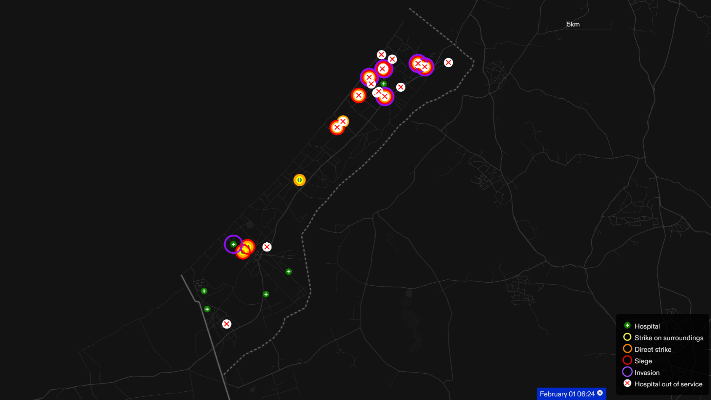
The Israeli legal team presented two cases alleging military use of hospitals at Al-Quds and Al-Shifa, neither of which offer sufficient evidence to justify the repeated attacks on those two hospitals. They presented these cases in response to claims that the Israeli military was deliberately targeting hospitals, in effect attempting to use these two weak cases to in turn justify all hospital attacks conducted by the Israeli military since the beginning of the war.
The Israeli legal team claimed that ‘hospitals have not been bombed’. Our research indicates that 13 hospitals have been directly attacked by Israeli forces since 7 October 2023, and at least 18 hospitals in the northern region of the Gaza strip were rendered inoperable, irrespective of whether any military justifications were provided by the Israeli military.
Our analysis of the attacks on hospitals in North Gaza reveals a consistent pattern of targeting hospital surroundings, followed by direct attacks, siege, and invasion. As the ground invasion extended to South Gaza, this same pattern was evident at Nasser and Al-Amal hospitals, the two primary healthcare facilities in Khan Yunis.
During the ICJ hearing, the Israeli legal team also repeated a disproven claim about the blast at Al-Ahli Hospital on 17 October 2023, ‘that the blast was the result of a failed rocket launch from within Gaza’. Our analysis of the 17 October blast at Al-Ahli Hospital demonstrates that the claims made by the Israeli military were based on false and misleading evidence and offer no substantive information as to the origin of the blast.
Israel has a history of making claims made based on misleading or false evidence. On 5 November 2023, an Israeli military spokesperson showed what he claimed to be a tunnel opening at Hamad Hospital. This was later shown by Al Araby TV, on 3 February 2024, to be a water reservoir.
Schools: Beit Hanoun UNRWA School
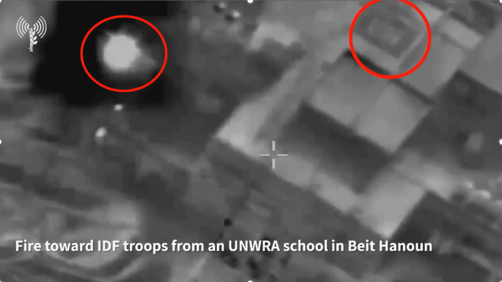
The Israeli legal team presented Evidence Figure 4 to support their claim that Palestinian fighters engaged in live fire from a UN School. The figure is a drone image annotated to mark an alleged moment of firing from the school and a UN sign on the roof of the building. They stated:
‘Here you can see militants firing from a United Nations school. You can see letters “UN” on the roof and the fire is circled in red.’
Analysis
In their statement, the Israeli legal team implied that Palestinian fighters jeopardised the school’s civilian status and hence civilian life. We examined the visual materials, the timing, and the applicability of this claim to this and other schools being used as shelters.
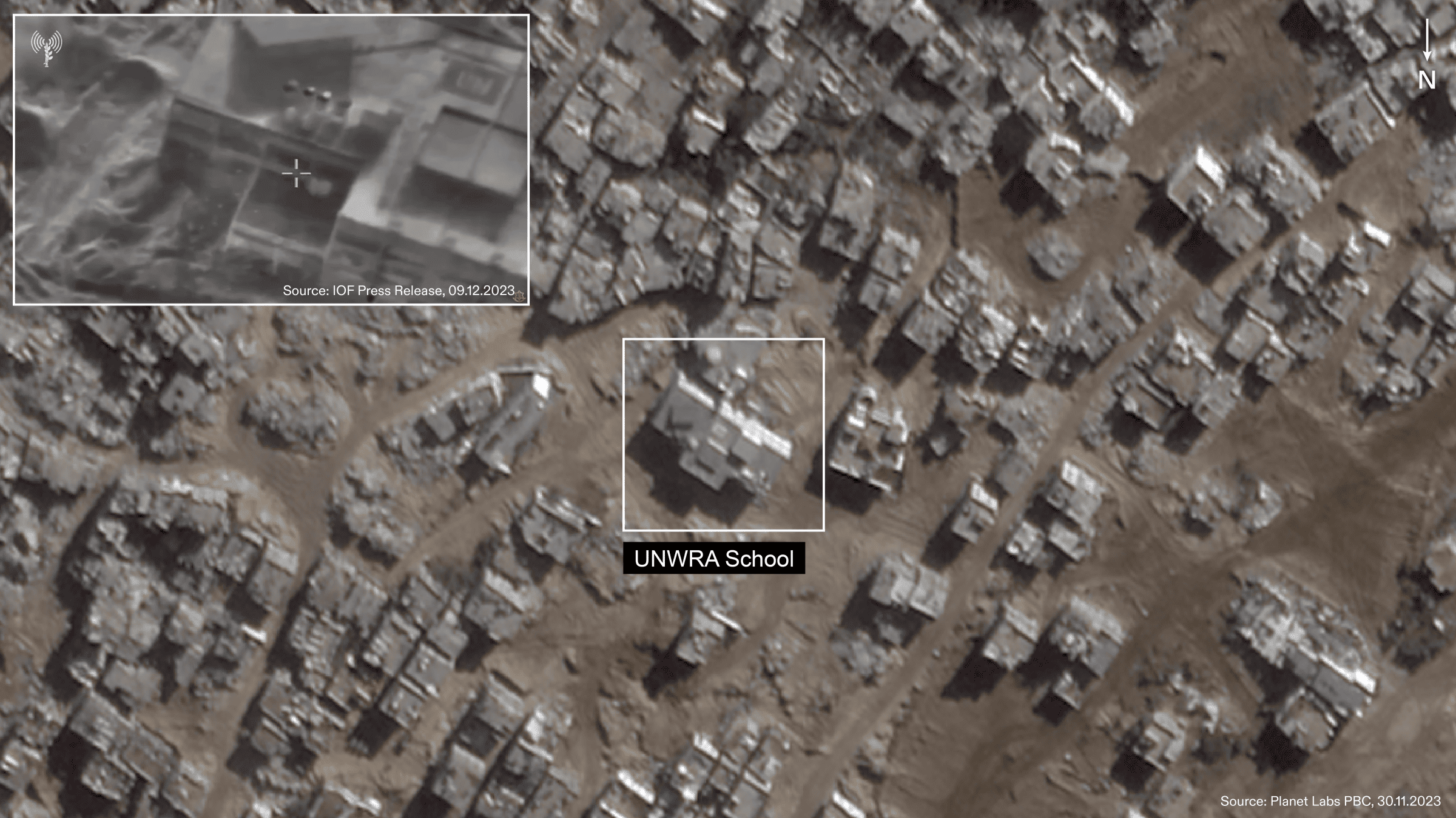
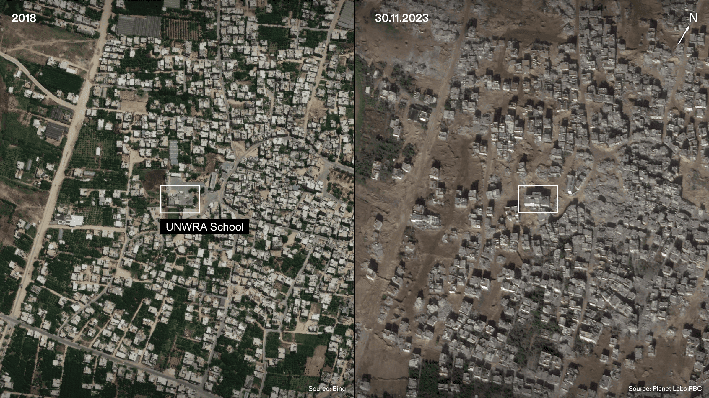
Evidence Figure 4 is a still from a video published on 9 December 2023 as part of an Israeli military press release. We geolocated the site at the following coordinates: 31.54240933, 34.53343297. Our satellite analysis suggests the video had been recorded between 4 and 9 December 2023.
The video shows road destruction, soil disturbance, heavy vehicle tracks, and dirt mounds around the building, indicating that Israeli forces had likely been present around the school before the video was taken.
Satellite imagery of Beit Hanoun shows widespread destruction, indicating the presence of Israeli forces, at the edge of Beit Hanoun as early as 31 October 2023. By 14 November 2023, further destruction was evident in the school’s immediate surroundings of the school by 14 November 2023.
The level of destruction around the school three weeks before the video was taken indicates a high level of Israeli military activity, making it unlikely that the building was being used as either a school or a shelter during that time.
Assessment
Our analysis indicates that it is unlikely the school building was being used as a school or as a shelter at the time the video (from which Evidence Figure 4 derives) was taken.
We found no further evidence of the school being used as shelter by civilians at the time the video was taken.
Context
The Israeli legal team presented Evidence Figure 4 in response to reports and statements made by the South African lawyers at the ICJ hearing suggesting that the Israeli military has targeted civilians and civilian property.
The Israeli legal team used Evidence Figure 4 to argue that these and other shelters and schools they have targeted have lost their protected status and are thus legitimate military targets. Just as they did for hospitals, the Israeli legal team used singular cases, themselves unproven and questionable, to deflect responsibility for all targeting of schools and shelters in Gaza.
According to United Nations Office for the Coordination of Humanitarian Affairs (OCHA), by 16 February 2024, ‘forty-five per cent of school buildings that have been used by IDPs as shelters, have been either directly hit or damaged’.
Civilian Residential Building
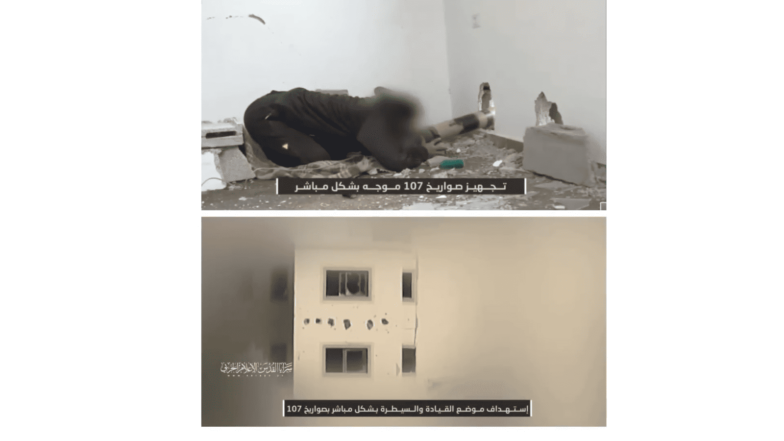
The Israeli legal team presented Evidence Figure 5 to claim Palestinian fighters were using residential buildings for military purposes with the following statement:
‘Houses, schools, mosques, United Nations facilities and shelters are all abused for military purposes by Hamas, including as rocket launching sites […] In the slides before you, you can see a militant priming projectiles for launch on IDF forces in Gaza. You can see the holes in the residential house to hide and launch them.’
The image and their statement alongside it imply that homes are legitimate targets, that Palestinian fighters put civilians at risks, that Israel only targets homes which are used by Palestinian fighters, and that Palestinian fighters are to singularly to blame for residential building destruction.
Analysis
The still image is part of a video published on 30 December 2023 by the media accounts of Hamas’s Al-Quds Brigades.
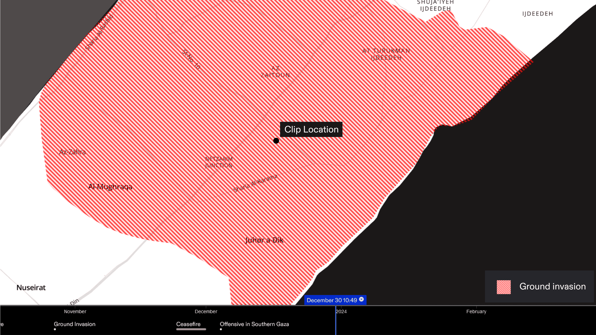
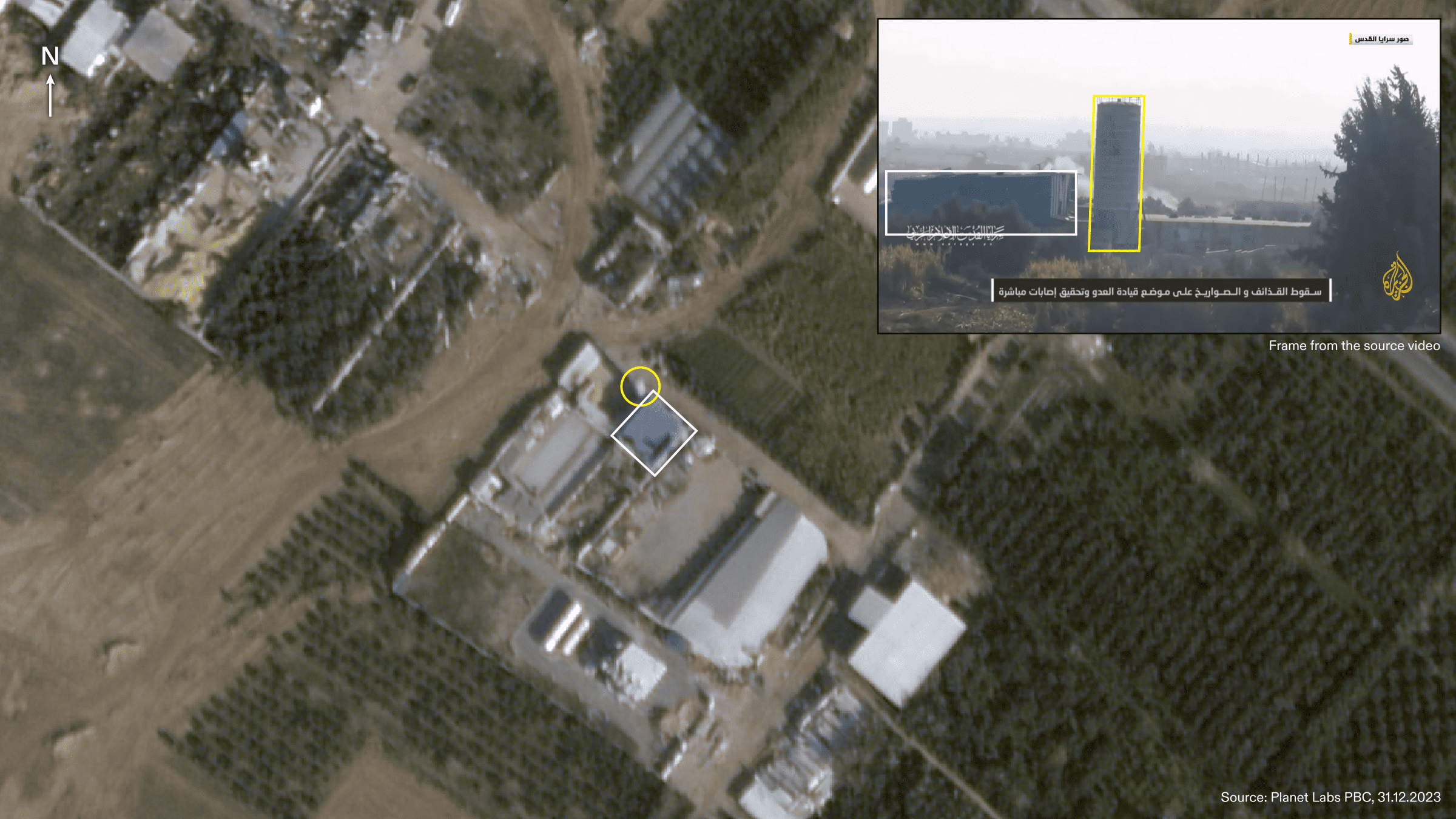
We identified the location of one of the clips to be on the southern edge of Zaytoun neighbourhood in Gaza City. The area captured in the footage is rural and sparsely populated, consisting primarily of agricultural land. At the time the video was recorded, the Israeli army had ground control of the area captured in the footage.
Assessment
We analysed the available footage and found it unlikely that the building in the image presented by the Israeli legal team during the ICJ hearing was in use by civilians or was an active civilian shelter.
Context
For the majority of Israeli attacks on residential buildings, the Israeli military has not provided evidence to justify the destruction of civilian property or death of civilians. Indeed, on many occasions Israel has struck residential buildings reported to be in active use by civilians. On 21 November 2023, the Israeli army struck the residential home of Dima Abdullatif AlHaj, killing over 50 members of her family and wider community sheltering within the property. To date, Israel has likely damaged or destroyed between 50% and 62% of buildings in the Gaza strip.
The Israeli army has been repeatedly documented occupying civilian homes in Gaza and the West Bank and using them for military purposes even as civilians are still inside. They have also been documented forcing civilians to stay put while they carry out attacks from their homes.
Humanitarian Zone
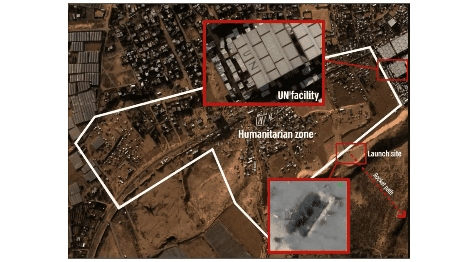
The Israeli legal team presented Evidence Figure 6 to claim Palestinians fired a rocket from close to a humanitarian zone and a UN facility in Rafah. When presenting this image, the Israeli legal team claimed:
‘You can see one example of a launch site adjacent to the humanitarian zone, both amplified in larger pictures’.
Analysis
Evidence Figure 6 is extracted from a video released by the Israeli military on 7 December 2023, displaying the site before and after an apparent launch. The video does not, however, show the moment of the actual launch. The location of the site is also outside the annotated ‘humanitarian zone’ boundary, in an unpopulated area 210 metres away from the UN facility and 85 metres from a tent camp.
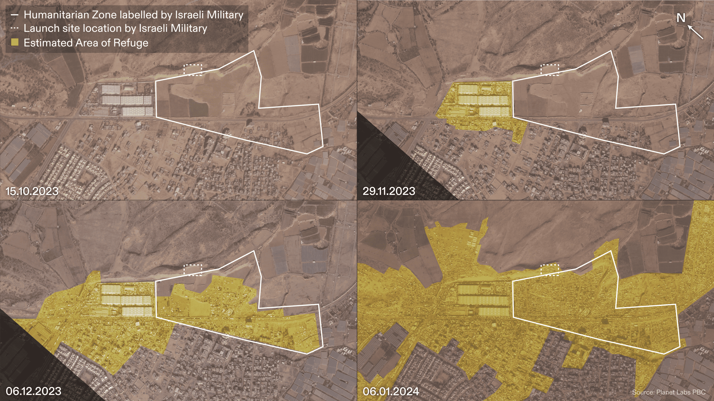
Evidence Figure 6 is a satellite image of an area in Rafah. In the image there is a building with a clear ‘UN’ demarcation on its roof. The Israeli military annotated the image with a label and white line marking the purported boundaries of a ‘humanitarian zone’. We confirmed that the image is from 6 December 2023 by comparing it to a series of other satellite images.
The white ‘humanitarian zone’ boundary in Evidence Figure 6 is not consistent with data from any other sources we referenced: it does not appear anywhere in the public domain and is not found in any sources cited by the Israeli legal team.
Moreover, the white line delineating the ‘humanitarian zone’ does not correspond to any of the 600 blocks into which the Israeli military divided the Gaza Strip supposedly to facilitate civilian evacuation. The shape and parameters of this boundary appear to be misleading and disingenuous in the context of Israel’s documented disregard for its own designated ‘humanitarian zones’.
Assessment
We found the annotation of Evidence Figure 6 to be misleading; no such ‘humanitarian zone’ boundary exists elsewhere in the public record.
Context
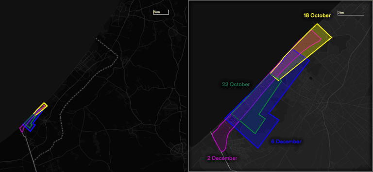
The boundaries of different supposed safe areas were not clearly defined or communicated, neither to Palestinian civilians seeking safety nor to the public, including human rights investigators monitoring attacks on these ‘safe zones’.
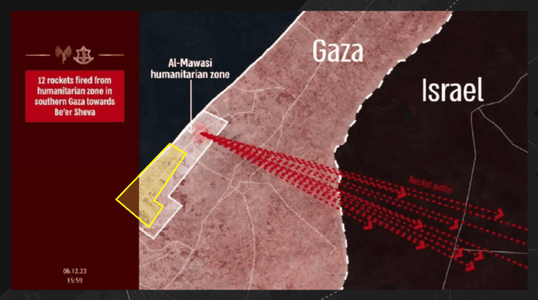
The boundaries of what the Israeli military calls ‘safe zones’ have been inconsistent, fluid, and ambiguous. For the Al-Mawasi ‘safe zone’ west of Khan Yunis, for example, the Israeli military released four different boundaries at different times.
The size and borders of the Al-Mawasi ‘safe zone’, as outlined by the Israeli military, vary significantly depending on the purpose of the mapping. When Palestinians were instructed to evacuate to Al-Mawasi, the ‘safe zone’ boundary encompassed only about half the area represented in the maps that were used to claim that Palestinian fighters had fired rockets from within the same ‘safe zone’.
Evacuation Orders and Safe Zones
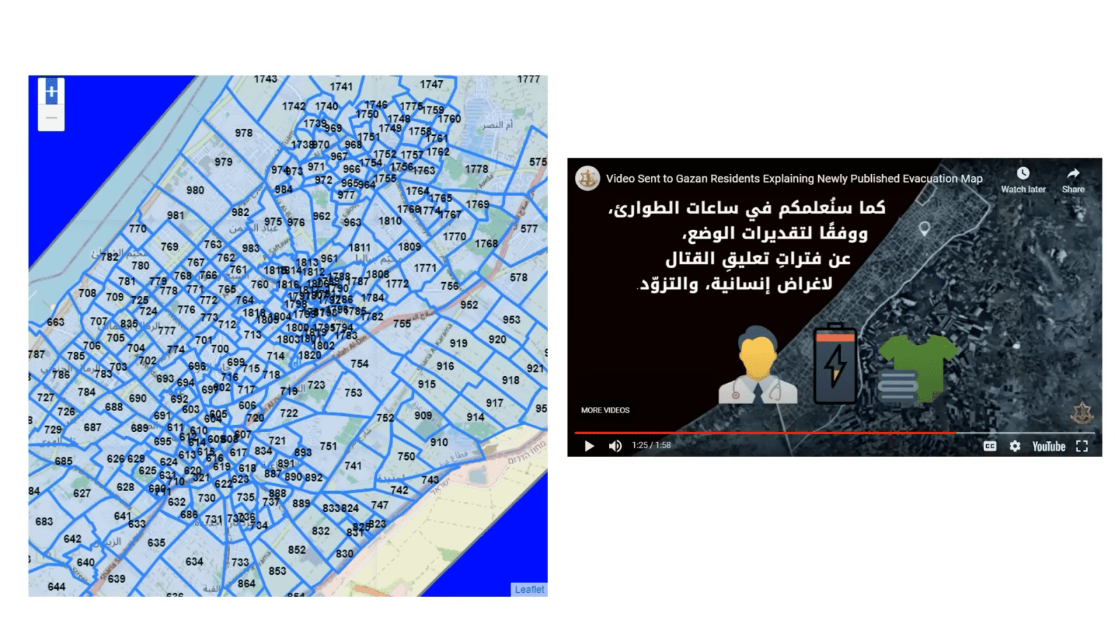
The Israeli legal team presented two slides (Evidence Figure 7 and Evidence Figure 8) in an attempt to refute the claim made by South Africa’s legal team that the way in which Israel ordered evacuations was intended to bring about the physical destruction of Palestinians. Alongside Evidence Figure 7, the Israeli legal team made the following statement:
‘The IDF maintains a Civilian Harm Mitigation Unit to undertake this task. It works full-time to provide advance notice of areas in which the IDF intends to intensify its activities, co-ordinate travel routes for civilians and secure these routes. This unit has developed a detailed map so that specific areas can be temporarily evacuated, instead of evacuating entire areas. On the slide before you, you can see that map, divided into areas, as well as a screenshot of a video explaining the system in Arabic so civilians may understand it. The IDF also enacts localised pauses in its operations to allow civilians to move. It does this even though Hamas does not agree to do the same and has even attacked IDF forces securing humanitarian corridors.’
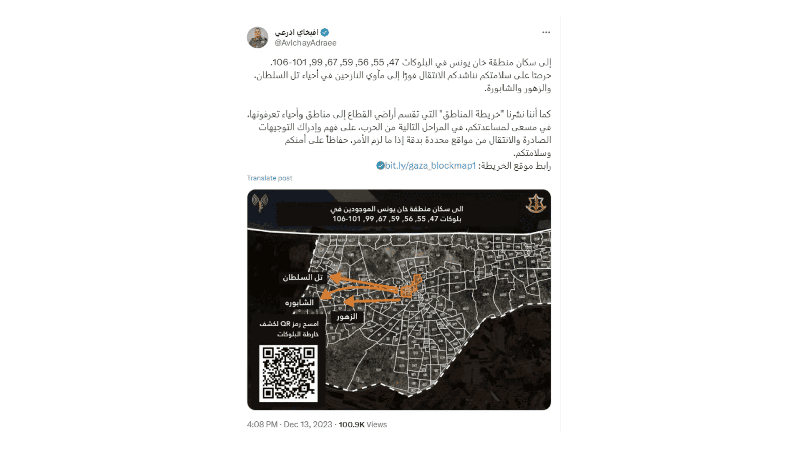
For Evidence Figure 8, the Israeli legal team claimed:
‘Here you can see the IDF’s Arabic Twitter account, providing information for civilians to evacuate specific areas, including the location of shelters nearby’.
Analysis
For a complete analysis of the claims Israel has made about ‘civilian harm mitigation’ as well of all evacuation maps made public by the Israeli military, see Forensic Architecture’s Humanitarian Violence Report (publication forthcoming).
The map on the left in Evidence Figure 7 was first published on 1 December 2023. The Israeli legal team claims that the map was developed for humanitarian purposes. This map, however, appears to have already been in use by the Israeli military as early as 7 October 2023 and was reportedly being used for military and construction planning already years before.
Evidence Figure 8, first published on 13 December 2023, offers an example of incomplete, erroneous, and misleading instructions published by the Israeli military. In this image, we found the following inconsistencies:
- Block 55 is listed but not represented in the map.
- Block 99 is listed but not fully covered in the map.
- Blocks 100 and 63 are both partially covered, despite not being listed in the written evacuation instructions.
Assessment
The Israeli legal team made misleading claims about the origin and purpose of the map they published. We also found that the Israeli legal team used an example of evacuation instructions that were misleading and contained multiple inconsistencies.
Aid
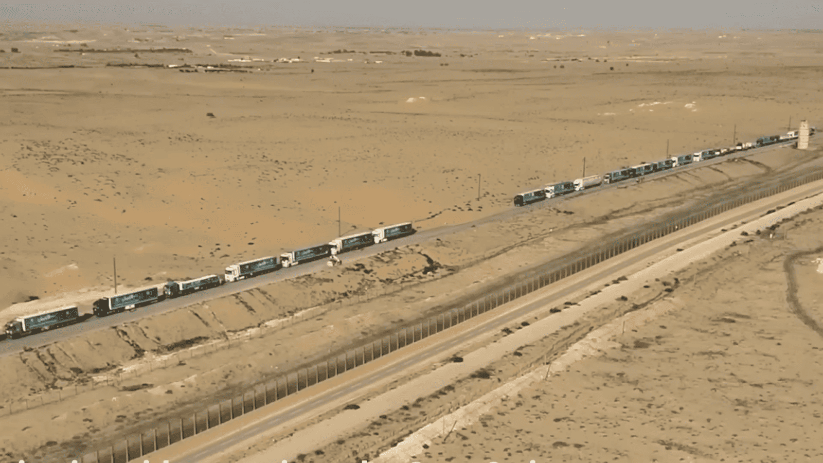
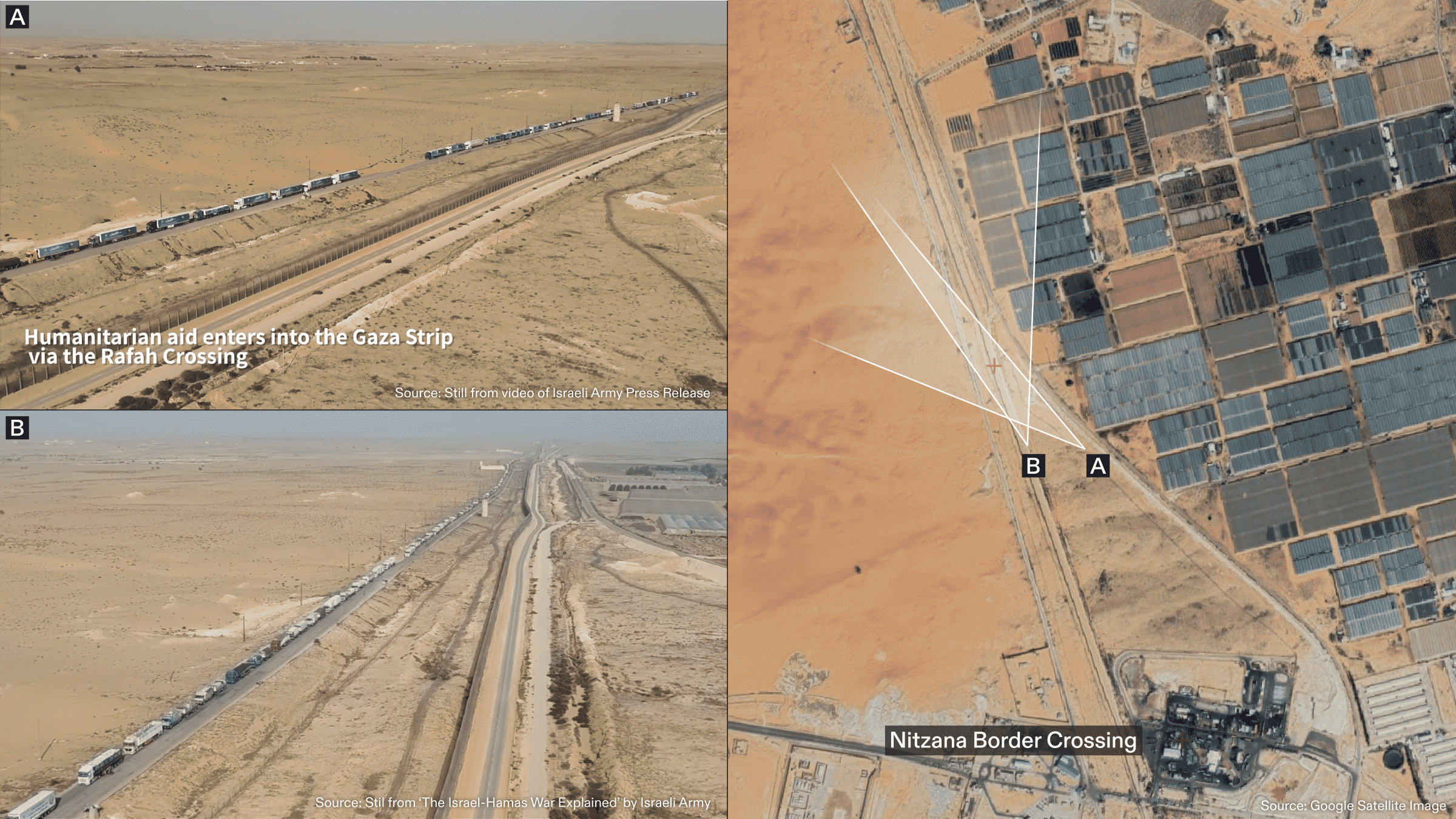
The Israeli legal team presented Evidence Figure 9 to claim that aid is entering Gaza:
‘And finally, more consignments waiting to enter Gaza’.
Analysis
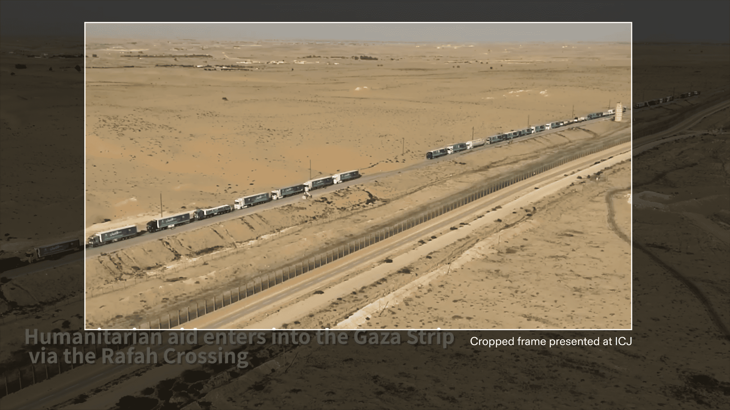
The still image is part of a video published on 24 November 2023 in an Israeli military press release. The area depicted is just outside the Nitzana border crossing. Evidence Figure 9 is seen in the video with the caption ‘Humanitarian aid enters-into Gaza Strip via the Rafah Crossing’ (Figure 25, top left).
We geolocated the footage and identified the location of the trucks to be approximately 41km from Rafah border, moving in the opposite direction towards the Nitzana border. The footage and caption are misleading because they claim the trucks were entering Gaza via the Rafah border; instead, they would have been checked by the Israeli army at the Nitzana border where there trucks have frequently been refused and aid has been confiscated. This will also drastically increase the timing of shipping.
We identified the location and direction of the trucks moving towards the Nitzana border, where they would first be checked by the Israeli army before being sent back to Rafah. On 24 November, OCHA reported that of 200 trucks dispatched from Nitzana, crossing to Rafah, only 137 trucks reached the UNRWA reception point in Gaza. Despite 63 trucks not making it through, at the time this was the most amount of aid to enter Gaza since 8 October.
Assessment
The Israeli legal team’s statement that the trucks seen in Evidence Figure 9 were waiting to enter Gaza is misleading. Moreover, they highlighted the first day of the humanitarian ceasefire when an uncharacteristically high number of aid trucks were ultimately able to pass into Gaza, compared to the days surrounding.
Context
24 November marked the beginning of the humanitarian pause. In the days prior, OCHA documents state that significantly less aid made it into Gaza, with only 290 trucks reaching Rafah from 20 to 23 November. Between 14 and 17 November, OCHA reported that Gaza received no humanitarian aid through the Egyptian-Israel border due to the depletion of fuel reserves, ceasing operation at the Nitzana crossing. This created a significant backlog of aid in the week prior to the Israel army’s press release on 24 November.
Gaza is accessible through three crossings. Beit Hanoun (Erez) and Karm Abu Salem (Kerem Shalom) crossings are controlled by the Israelis, who had kept the two sites closed until 17 December, when Karm Abu Salem was reopened (Beit Hanoun remains closed). The third crossing at Rafah, located on the Egypt-Gaza Border, was the only open entrance for humanitarian aid into Gaza on 24 November.
Although crucial for the provision of aid in Gaza, the Rafah crossing was consistently targeted by Israeli airstrikes between 9 and 16 October, resulting in the closure of this crossing until 21 October. On 23 October, OCHA reported a new agreement had been reached for the processing of humanitarian aid between Egypt and Gaza. This process diverted trucks 40km south of Rafah, to the Nitzana crossing between Egypt-Israel for inspection by Israeli authorities, with trucks then travelling back to Rafah to enter Gaza.
Since this change in the processing of humanitarian resources, reports have highlighted that the provision of aid has been significantly impacted by delays. UNRWA’s director of communications stated that humanitarian operations and the delivery of trucks had become ‘cumbersome’ and ‘unnecessarily complex’, a process slowed by arbitrary and vague inspections and denial of access to aid trucks.