Methodologies
Forums
Building on Forensic Architecture’s previous investigation into herbicidal warfare and its effects on Palestinian farmers along the eastern perimeter of the occupied Gaza Strip, this investigation marks Land Day in Palestine by examining the systematic targeting of orchards and greenhouses by Israeli forces since October 2023. Our analysis reveals that this destruction is a widespread and deliberate act of ecocide that has exacerbated the ongoing catastrophic famine in Gaza and is part of a wider pattern of deliberately depriving Palestinians of critical resources for survival.
Since 2014, Palestinian farmers along Gaza’s perimeter have seen their crops sprayed by airborne herbicides and regularly bulldozed, and have themselves faced sniper fire by the Israeli occupation forces. Along that engineered ‘border’, sophisticated systems of fences and surveillance reinforce a military buffer zone.
Since October 2023, Israel’s ground invasion has uprooted most of these orchards and systematically targeted agricultural farmlands and infrastructure throughout the besieged Strip.
This investigation builds on our existing collaborations with local farmers’ associations and agricultural workers, to reveal the ongoing Israeli destruction of vegetation in Gaza and its effects on the food security and means of life for Palestinians.
Last remaining orchards
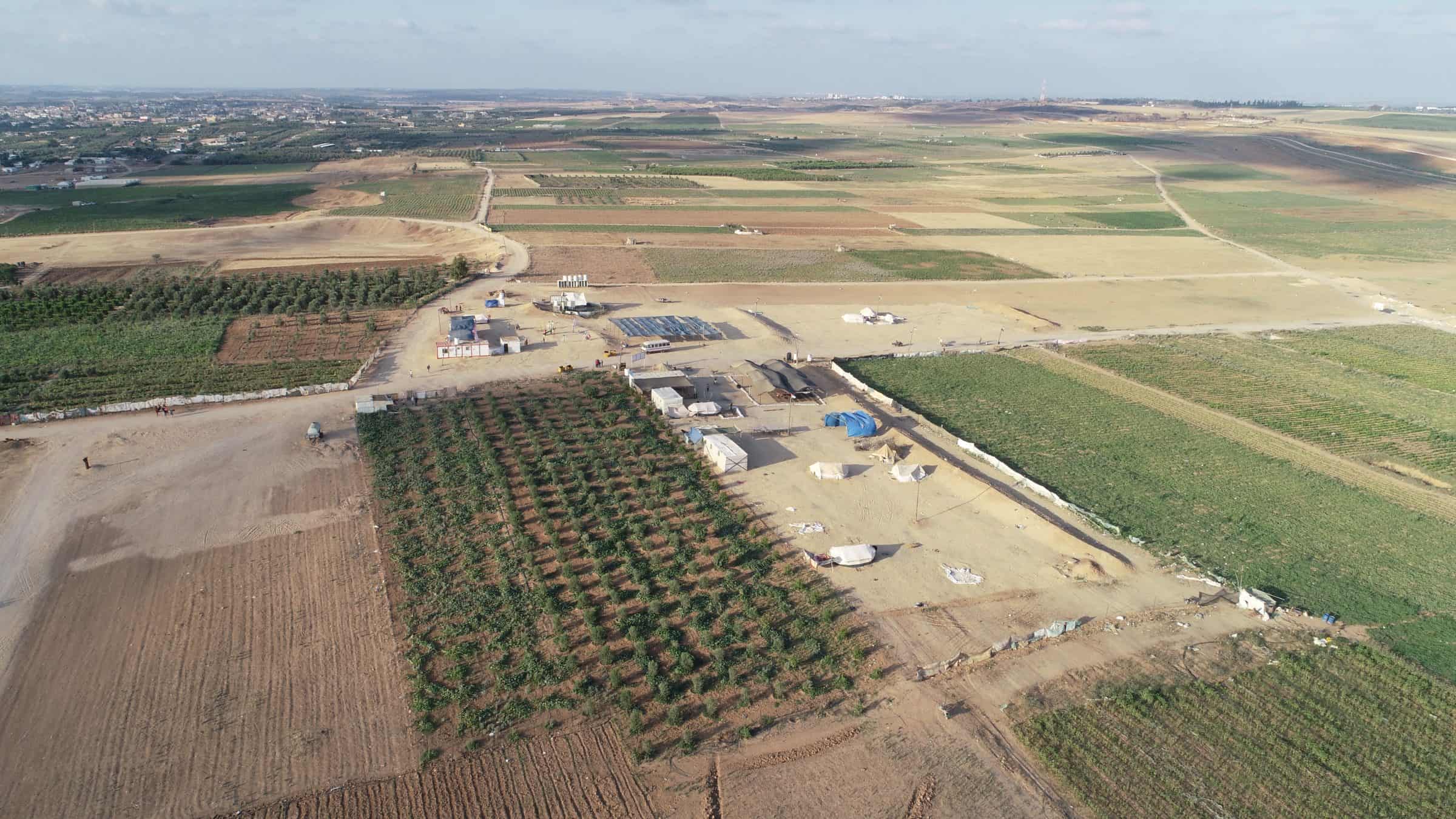
For the past decade, the Abu Suffiyeh family has cultivated one of the last olive, pomegranate, and citrus orchards along the eastern perimeter of Gaza, in a district called East Jabaliya.
Directly facing the Israeli-imposed buffer zone, these orchards and the lands cultivated by other farmers in this area were often threatened by bulldozing by the Israeli occupation forces, which declared that any vegetation higher than 1 metre in the vicinity of their military ‘no-go’ area is a security threat, and must be flattened. In this way, the continued existence of the Abu Suffiyeh farm and its neighbours confronted the colonial imaginary of a flattened Gazan landscape.

Later, during the 2018 civilian protests, known as the Great March of Return and the Breaking of the Siege, the areas surrounding the Abu Suffiyeh farm became a gathering place for protesters confronting the occupation.
Even as the decades-long Israeli blockade of the Gaza Strip prevented access to clean water and vital farming materials, through careful and assiduous tending, Abu Suffiyeh’s orchard nevertheless grew tall.

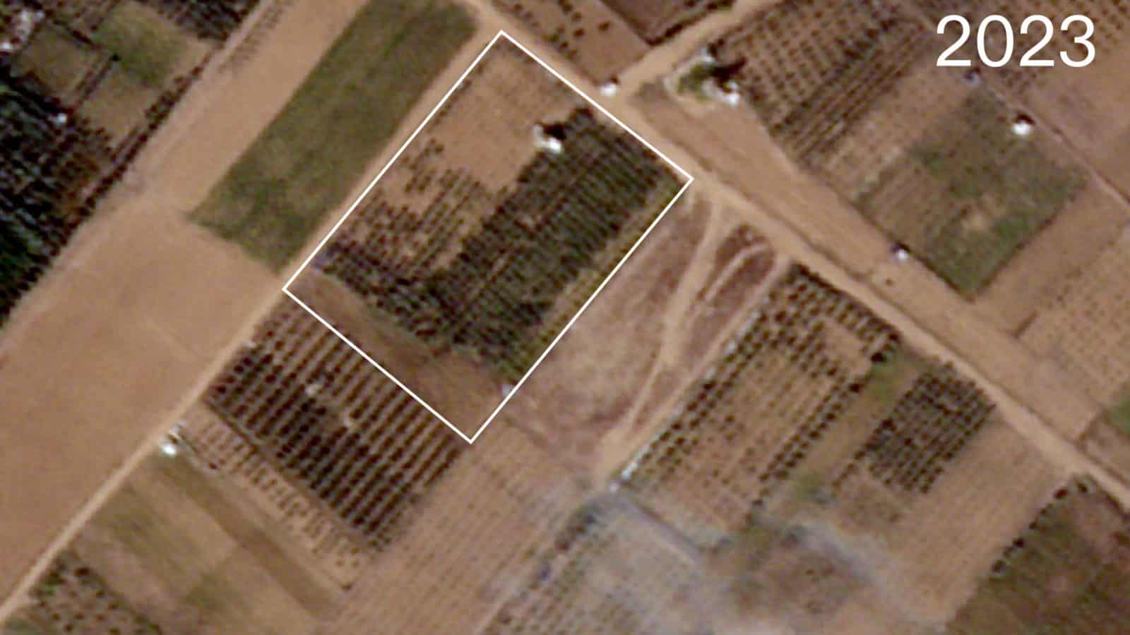
But the family’s efforts to preserve their land were unable to withstand the recent Israeli military incursions: satellite imagery from January 2024 shows that the farm was destroyed by the Israeli ground invasion. Earth berms have been raised by bulldozers to create military bases, and a new road has been carved through the landscape.

Together, these earthworks have transformed a previously productive Palestinian agricultural area into a colonial military outpost.
Using satellite and aerial images, we were able to trace the changing landscape of the Abu Suffiyeh farm and neighbouring agricultural lands over decades. Historical aerial photography shows Palestinian fields and orchards in the area before the Israeli occupation in 1967. Despite the Israeli land expropriation and nearby settlement construction that followed, cultivation continued for decades, until the 2000s, when this agriculturally rich area was uprooted and flattened to build roads and infrastructure to support the illegal settlements. Following the removal of the Israeli-Jewish settlements in 2005, despite regular attacks and lack of access to key farming materials, Palestinian farmers like the Abu Suffiyeh family were able to successfully restore the land.

Taken together, this analysis reveals persistent Palestinian cultivation of these farmlands in the face of forced changes to the landscape by the Israeli occupation.
Ecocide in Gaza
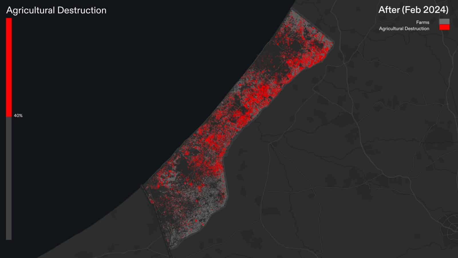
Prior to 2023, Gaza contained 170 square kilometres of agricultural land, accounting for about 47 percent of its total area. These fields and orchards served as a local source of food security for besieged Palestinians.

Our analysis shows that Israel’s ground invasion has advanced over nearly 50 percent of Gazan farms and orchards. We used remote sensing to measure the scale of agricultural destruction resulting from this military activity, by comparing the region’s ‘vegetation index’ (an indicator of the health and robustness of plant life, measured by analysing satellite imagery) before and after the invasion. This comparison reveals that as of March 2024, of the agricultural areas targeted, approximately 40 percent of the land in Gaza previously used for food production has been destroyed.

The uprooting of agriculture along Gaza’s perimeter may also indicate that the Israeli army is expanding its ‘buffer zone’, further shrinking the liveable space for Palestinians.

Targeting agricultural infrastructure
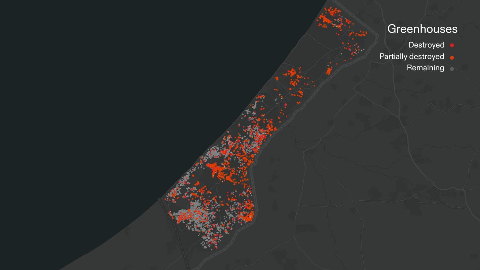
Vital agricultural infrastructure such as greenhouses has also been systematically destroyed since the launch of the ground invasion.
In the early weeks of the Israeli ground invasion, satellite imagery shows extensive destruction of greenhouses where, between October 2023 and March 2024, nearly one third of Gaza’s greenhouses have been destroyed.

In total, Forensic Architecture has identified more than 2,000 agricultural sites, including farms and greenhouses, which have been destroyed since October 2023, often to be replaced with Israeli military earthworks.
This destruction has been most intense in the northern part of Gaza, where 90 percent of greenhouses were destroyed in the early stages of the ground invasion.

As the Israeli military advances south, destruction of agricultural land and infrastructure moves with it. We observe that 40 percent of the greenhouses in the areas around the southern city of Khan Younis, where many hundreds of thousands of Palestinians are now displaced, have been destroyed since January 2024.

Military support vehicles and tractors accompany the Israeli ground invasion, routinely building earthworks to reinforce military outposts. Once those vehicles depart, they leave behind a devastated and unliveable area.

The destruction of agricultural land and infrastructure in Gaza is a deliberate act of ecocide and a critical dimension of Israel’s genocidal campaign. The targeted farms and greenhouses are fundamental to local food production for a population already under a decades-long siege. The effects of this systematic agricultural destruction are exacerbated by other deliberate acts of deprivation of critical resources for Palestinian survival in Gaza. These acts include, the well-reported catastrophic and Israeli-made famine ongoing in Gaza, continued obstruction of humanitarian aid destined for Gaza, the destruction of medical infrastructure, the destruction beyond repair of other areas of civilian infrastructure, including bakeries, schools, mosques, churches and cultural heritage sites.
Update
 20.08.2024
Since October 2023, we have documented the clearing of farms and orchards east of Gaza City belonging to the now-displaced Abu Suffiyeh family. Between November 2023 and June 2024, satellite imagery shows that the majority of Palestinian homes and farmland within 1km of the eastern perimeter of Gaza had been cleared by Israeli forces, and a new road constructed providing direct military access to Gaza City.
Our analysis of satellite imagery from November 2023 through July 2024 reveals evidence of a new Israeli military corridor east of Gaza City. This new corridor constitutes the second Israeli-built east-west passage through Gaza, after the so-called ‘Netzarim Corridor’. Together, these corridors are infrastructural indications of an intended permanent Israeli military presence in the northern parts of the occupied Gaza Strip.