Methodologies
Location
Publication Date
Forensic Architecture was commissioned by Adalah: The Legal Center for Arab Minority Rights and Gisha: Legal Center for Freedom of Movement to produce an analysis of the available satellite and ground-level imagery of the Port of Gaza’s destruction by Israeli forces. We studied Israeli attacks on the port between October 2023 and January 2024 to assess the approximate number of fishing vessels impacted and specifically examined the state of two vessels belonging to the Al-Hassi family, whose case is currently being represented by Adalah and Gisha in the Haifa District Court.
Our analysis reveals that the port was subjected to repeated Israeli airstrikes within the first weeks of the Israeli military campaign in Gaza. As early as 11 October 2023, Israeli aerial bombardment prevented pedestrian access to large sections of the port as well as the fishing vessels docked there. Roughly 40% of all vessels docked at the port appeared to have been rendered non-operational within the first week of Israel’s aerial campaign, according to available satellite imagery. By 10 January 2024, all remaining vessels in the port had been destroyed.
The Palestinian Fishing Industry
For centuries, fishing has played a significant part in the Palestinian economy, culture, and cuisine. Prior to the Nakba of 1948, the Mediterranean Sea provided around 80% of the total fish produce in Palestine, making the fisheries sector a key source of food and employment in Palestinian villages.1 In 1948, when Zionist paramilitary organisations forcefully displaced hundreds of thousands of Palestinians from fishing towns and villages along the Mediterranean, many fishermen fled to Gaza in the south. Today, the majority of the fishermen in Gaza are descendants of refugees from the Palestinian fishing villages that were ethnically cleansed in 1948.
Israel has been imposing restrictions on Palestinian access to and use of the sea since the 1990s. Since the 1995 Oslo II Accord, the fishing limit (the distance from shore within which fishing is permitted) has been restricted to 20 nautical miles from the coastline. In 2009, the Port of Gaza came under siege when Israel imposed a strict naval blockade on Gaza, under which it located its naval forces close to Gaza’s shores. Within the area of the blockade, Israel imposed additional restrictions on fishing and travel. To this day, such restrictions are arbitrarily adjusted by the Israeli navy. The fishing limit, for example, may range from zero nautical miles up to a maximum of fifteen during less restrictive periods, effectively suffocating Gaza’s historic fishing industry.
While the permitted fishing limit has fluctuated since the Oslo II Accord, the intensification of Israeli fishing restrictions and military siege nevertheless resulted in repeated and continuous attacks on Palestinian fishermen working within the Israeli-restricted fishing limit.2
Palestinian fishermen have regularly reported3 being fired on by the Israeli Navy while fishing, killing numerous fishermen throughout the years, including other attacks such as arbitrary violent arrests, confiscation, destruction of their fishing vessels, and the destruction of their fishing equipment, among other devastating practices.
Destroying Gaza's Historic Port
Located near the Rimal district of Gaza City, the Port of Gaza has historically housed Palestinian fishing vessels that operate along occupied Gaza’s 41km coastline. Of those 41km, the port constitutes just 650m, or 4% of the coastline, despite being the main port in Gaza.
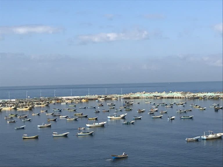
Though Israeli restrictions and violent attacks on fishermen have significantly diminished the fishing industry in Gaza, the port had remained active, with Gaza’s fisheries continuing to serve a central role in both local job creation and food security. The destruction that we have documented here is the latest development in a decades-long history of violent Israeli occupation and siege on Gaza’s sea space.
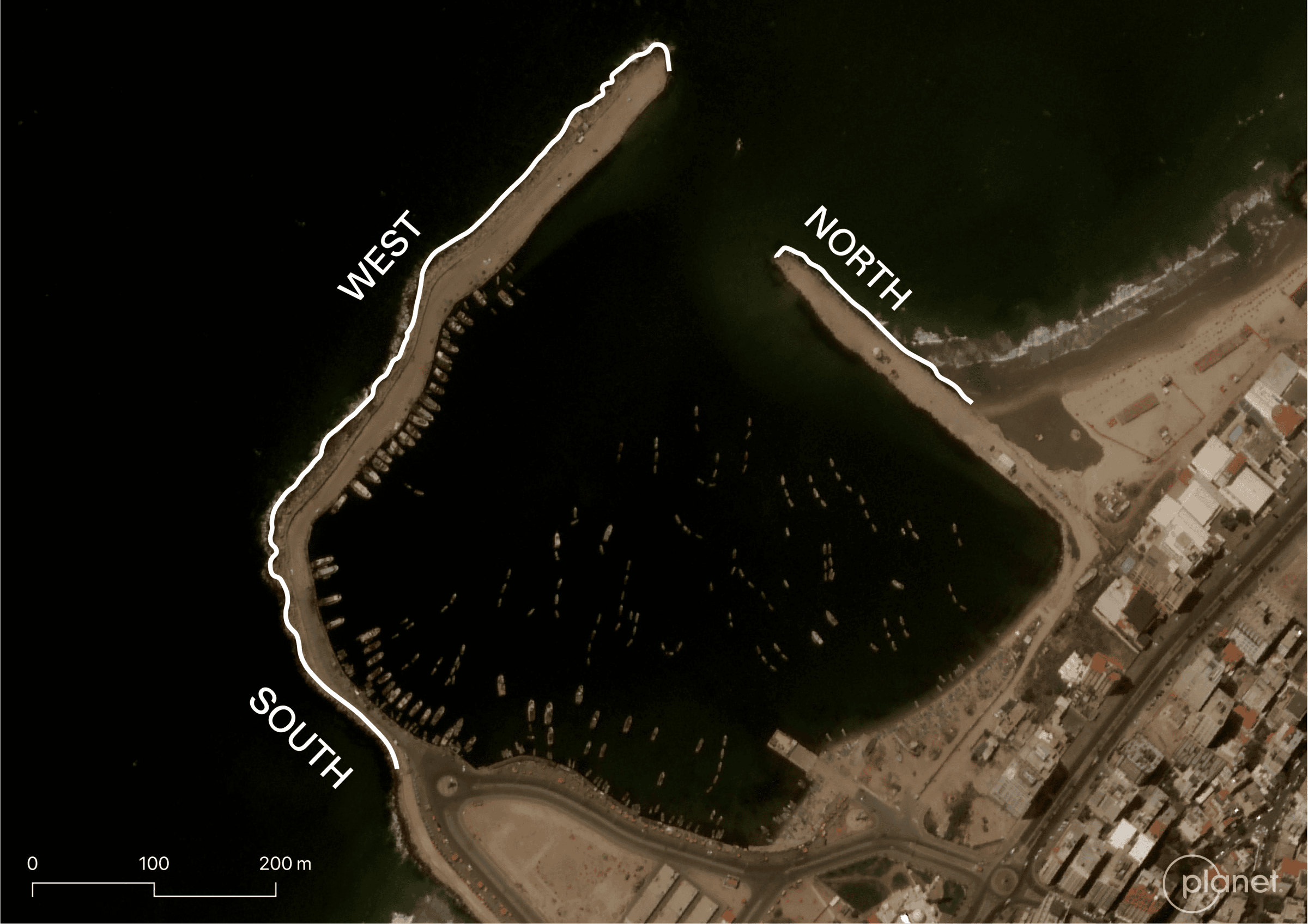
Gaza’s historic port is defined and delimited by a curved sea wall. Satellite imagery from 11 October 2023 documents the first visible damage to the port: a crater in the southern sea wall.
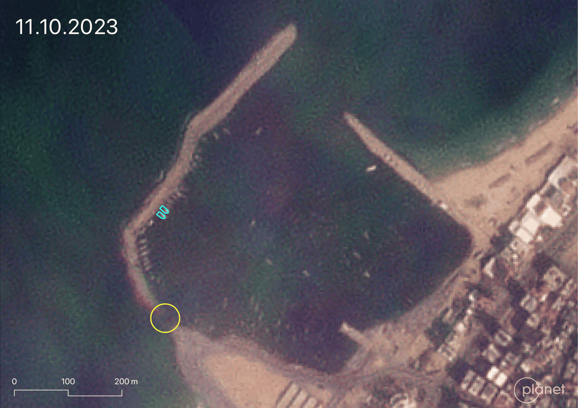
With a diameter of approximately 22 metres, this crater obstructed pedestrian access to the vessels docked along the southern and western sections of the curved sea wall. Our analysis of ground-level imagery confirms that this damage was the result of an Israeli airstrike.
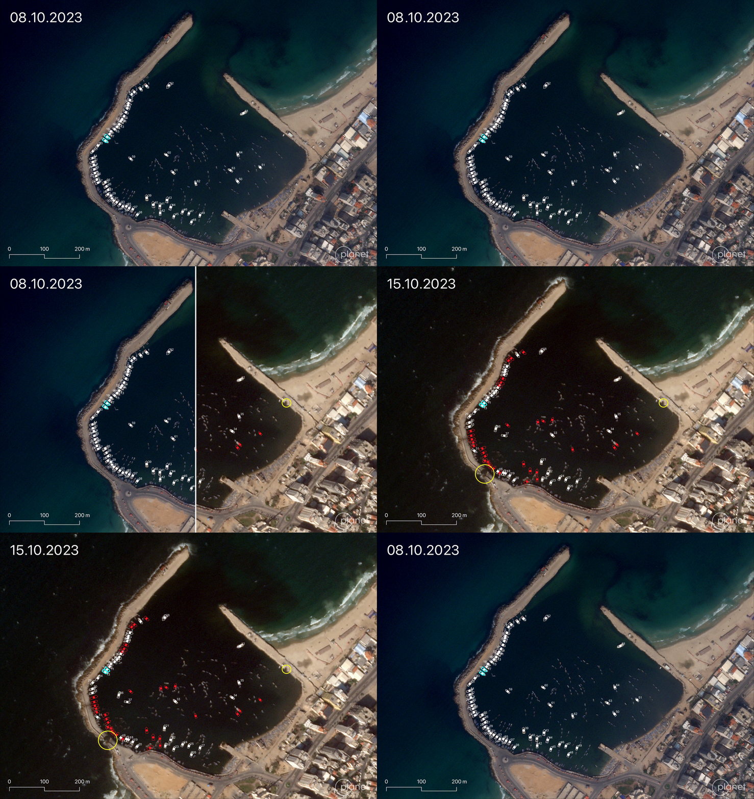
Satellite imagery from 8 and 15 October 2023 reveals that the number of operational fishing vessels in the port decreased by nearly half over the course of that week. While a small proportion of these vessels may have been relocated, the majority (marked in red) have sustained visible damage, and many as a result appear partially submerged.
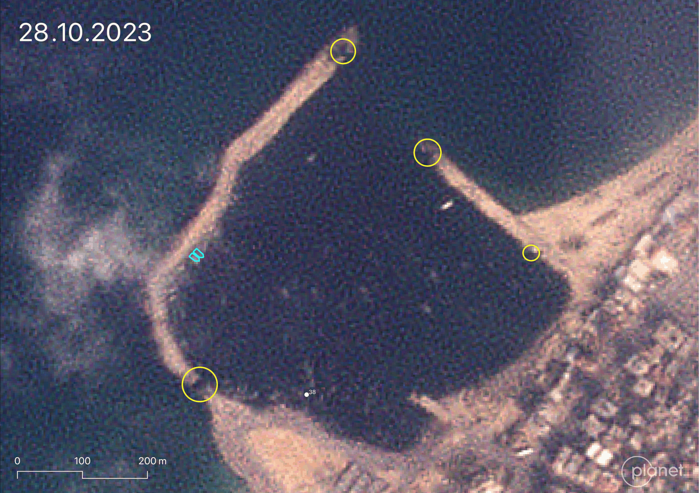
After the start of the Israeli ground invasion in the north of Gaza on 28 October 2023, the port sustained further damage. Our analysis of satellite imagery from 28 October 2023 identified two new craters at the ends of the north and west sea walls (annotated in yellow), indicating that the port was subjected to additional airstrikes after 15 October 2023.
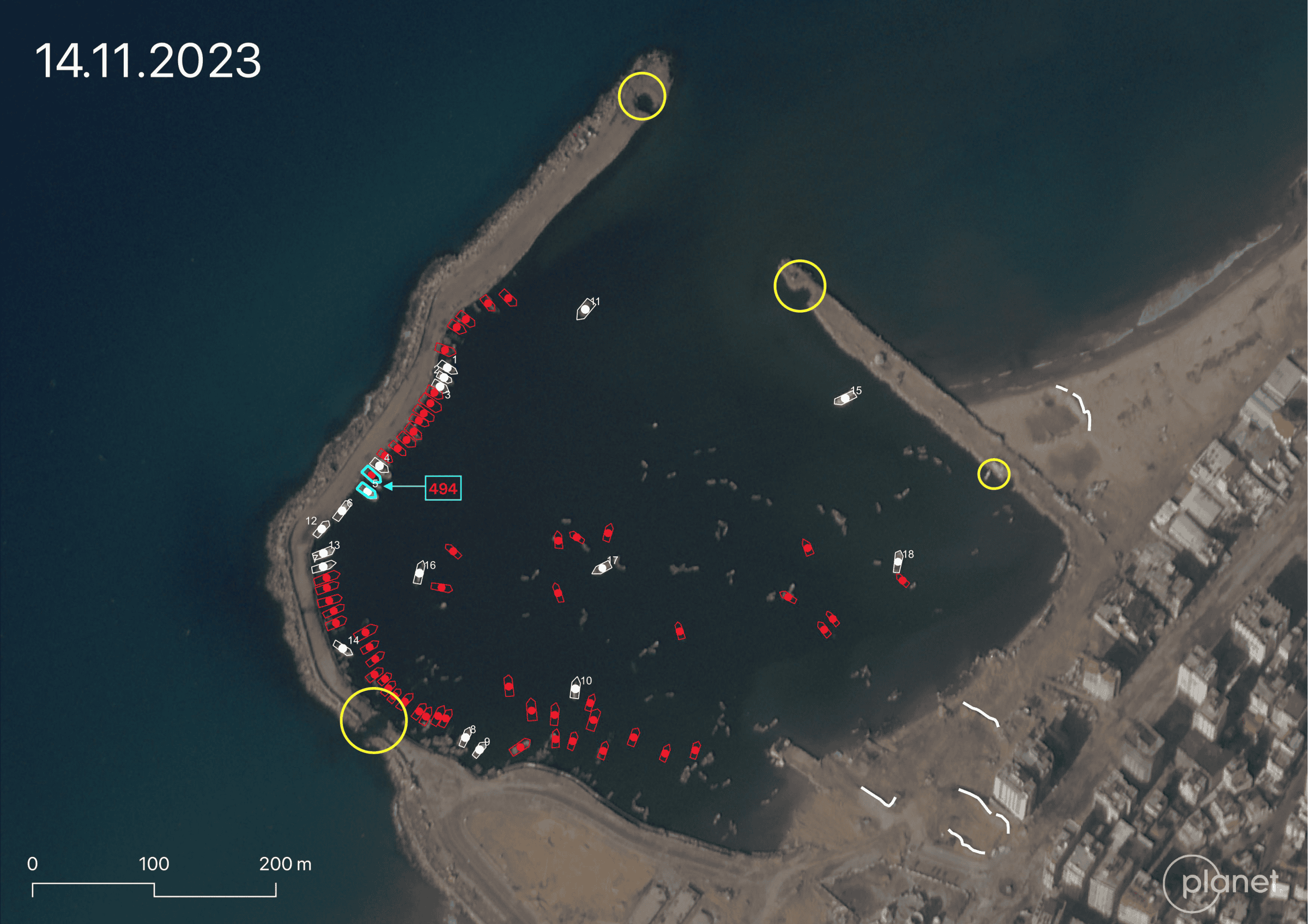
The image above from November 2023 (Fig. 6) shows the presence of earth berms (annotated in white) on the beach, indicating Israeli military presence around the port at this time.
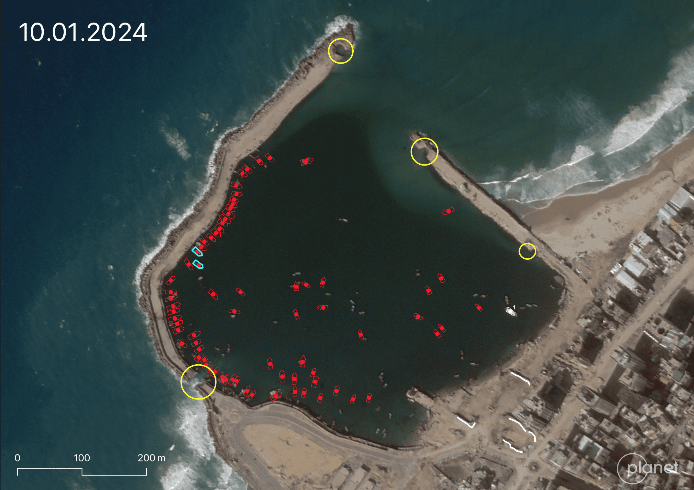
In the months that followed, the port was regularly attacked and the Palestinian fishing vessels inside the port were gradually destroyed, sinking partially or completely into the sea. Satellite imagery revealed that by 10 January 2024, all vessels originally observed had been rendered non-operational.
‘Condemned’ Vessels: the Case of the Al-Hassi Family
Trained as skilled fishermen and traders for generations, many members of the Al-Hassi family in Gaza rely on the local fishing industry as their main source of livelihood.
In February 2022, Israel illegally captured a vessel belonging to Jihad Al-Hassi from Gazan waters, claiming that it had violated Israeli ‘naval restrictions’ within Gaza’s blockaded sea area. The State of Israel submitted an unprecedented request4 to the Haifa District Court (in its capacity as the Maritime Court) demanding that the court give Israel authority to permanently confiscate the vessel. Known as ‘condemnation requests’ under prize law, such cases of permanent confiscation invoke colonial British mandate-era laws—the same laws previously used to condemn the Gaza Freedom Flotillas challenging Israel’s illegal occupation and blockade.
In November 2022, as the legal case in the Haifa District Court was underway, the Israeli Navy seized another fishing vessel belonging to Mohammed Al-Hassi, Jihad’s nephew, who inherited the vessel from his father in 2021. During the violent capture of the vessel, the Israeli Navy shot one of the fishermen aboard the boat in the neck and face. Other fishermen onboard and in the vicinity were arrested, taken to Israel, and released the next day.
After being seized by the Israeli Navy, both vessels were returned to the family for a bond payment and docked again at the Port of Gaza. Following the events of 7 October 2023 and the subsequent destruction of the port and the vessels within it, Gisha and Adalah submitted a request to dismiss the State’s charges on the grounds that, to the best of the fishermen’s knowledge, the vessels had been destroyed by Israeli forces.
In his affidavit to the court, Jihad outlined the following: in early November 2023, he and all his family members, including Mohammed, fled their home in the Rimal neighbourhood of Gaza City to seek shelter in Rafah. On their way south, he noticed the two vessels still docked at the fishermen’s port. Around ten days later, a relative informed him that Israeli forces had destroyed both vessels, along with numerous others stationed in the port. The relative was unable to capture visual documentation of the destroyed vessels due to restricted access to the port and the imminent threat to life posed by Israeli airstrikes and military operations in and around the port.
Gisha and Adalah’s request for dismissal of the case was denied, as was their appeal for dismissal to the Israeli Supreme Court. In its response, Israel requested proof of the current state of the two vessels in question. Israel rejected the organisations’ argument that this information should already be in the State’s possession given their military operations around the port.
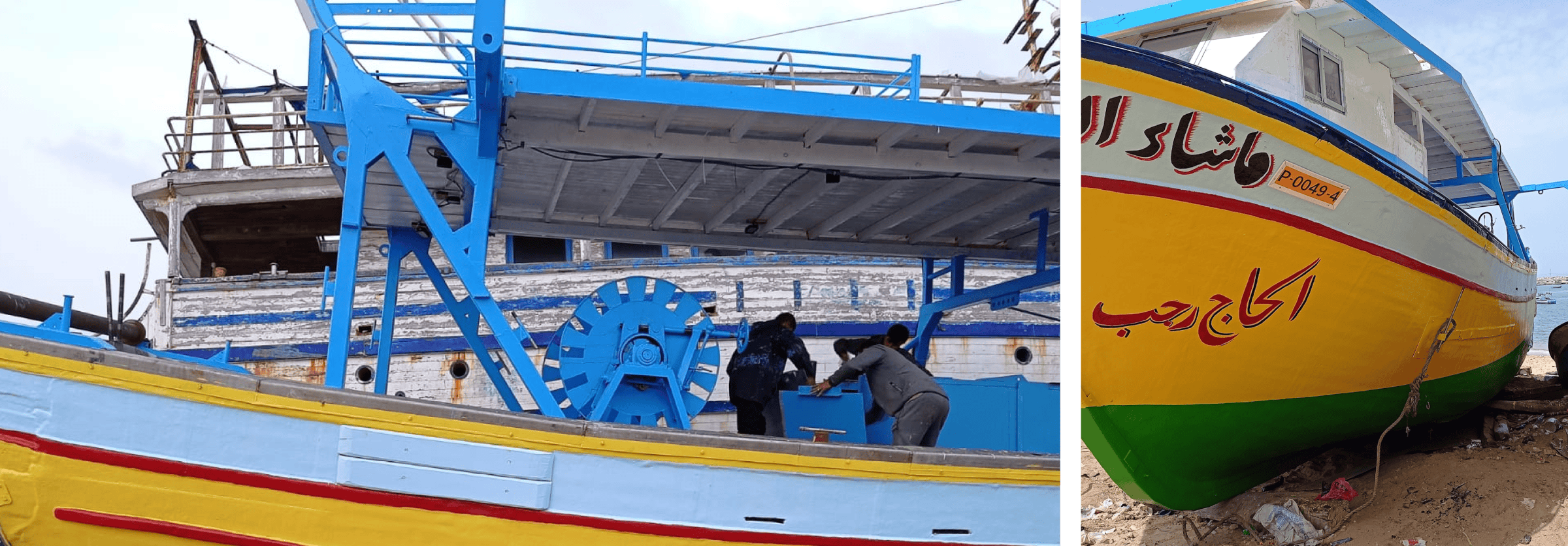
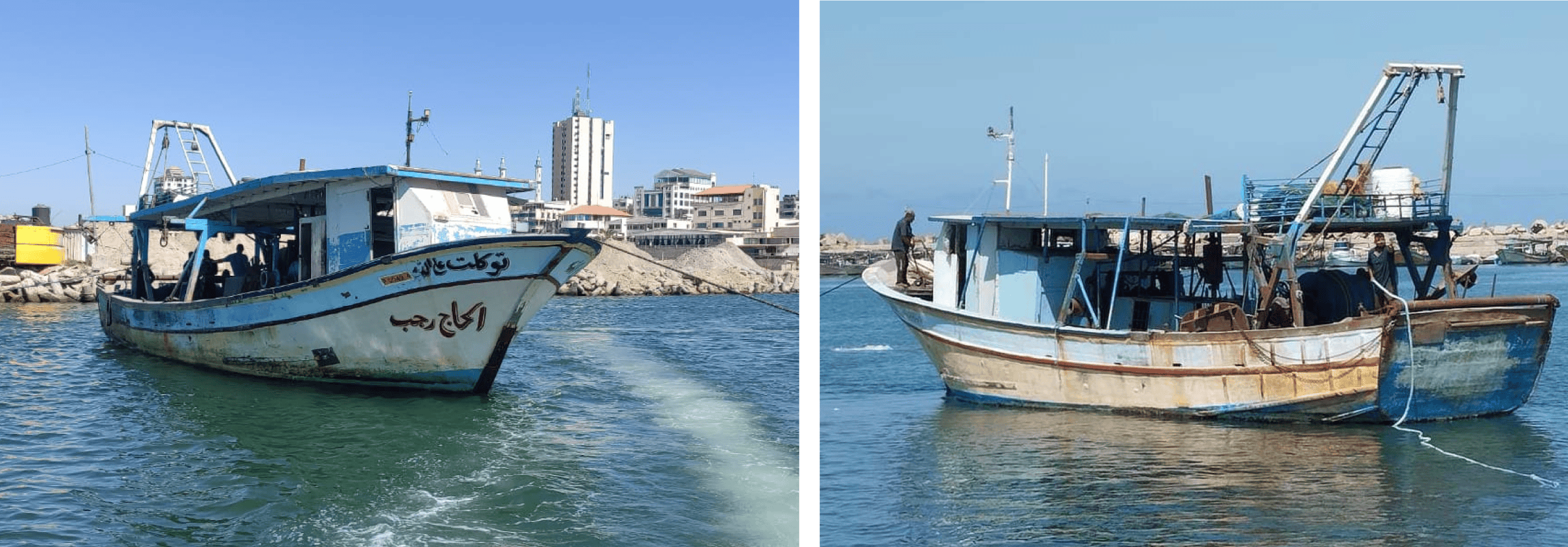
The two vessels belonging to the Al-Hassi family are trawler/‘lanch’ boats. Vessel No. P-000494 (Fig. 8) belonged to Jihad, and vessel No. P-000474 (Fig. 9) to Mohammed.
Using satellite images and ground-level and archival photographs of the two vessels, we established a timeline of visual evidence of the state of vessels No. P-000494 and No. P-000474 spanning from October 2023 to November 2024. Images provided to us by Adalah and Gisha of the vessels allowed us to measure their dimensions and identify their main features, including colour, shape, and mounted equipment, such as a ladder. Through satellite imagery analysis, we determined the approximate size of vessels No. P-000494 and No. P-000474, assessing them to be around 18 and 19 metres in length, respectively.
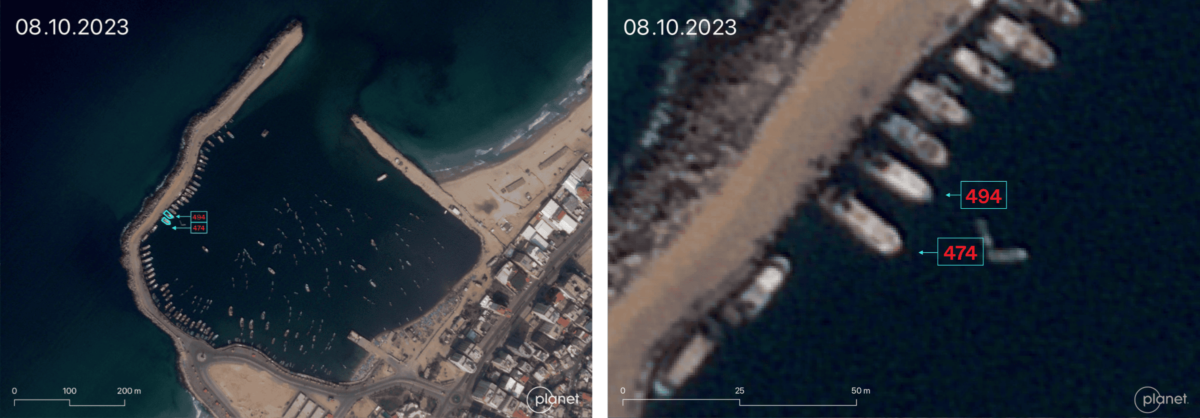
Our analysis of satellite imagery from 8 October 2023 shows both vessels docked along the western section of the port’s sea wall. Satellite imagery from three days later, on 11 October 2023, shows that the two vessels remained docked in the same location after the first airstrike on the south section of the port’s curved sea wall had cut off pedestrian access to the vessels.
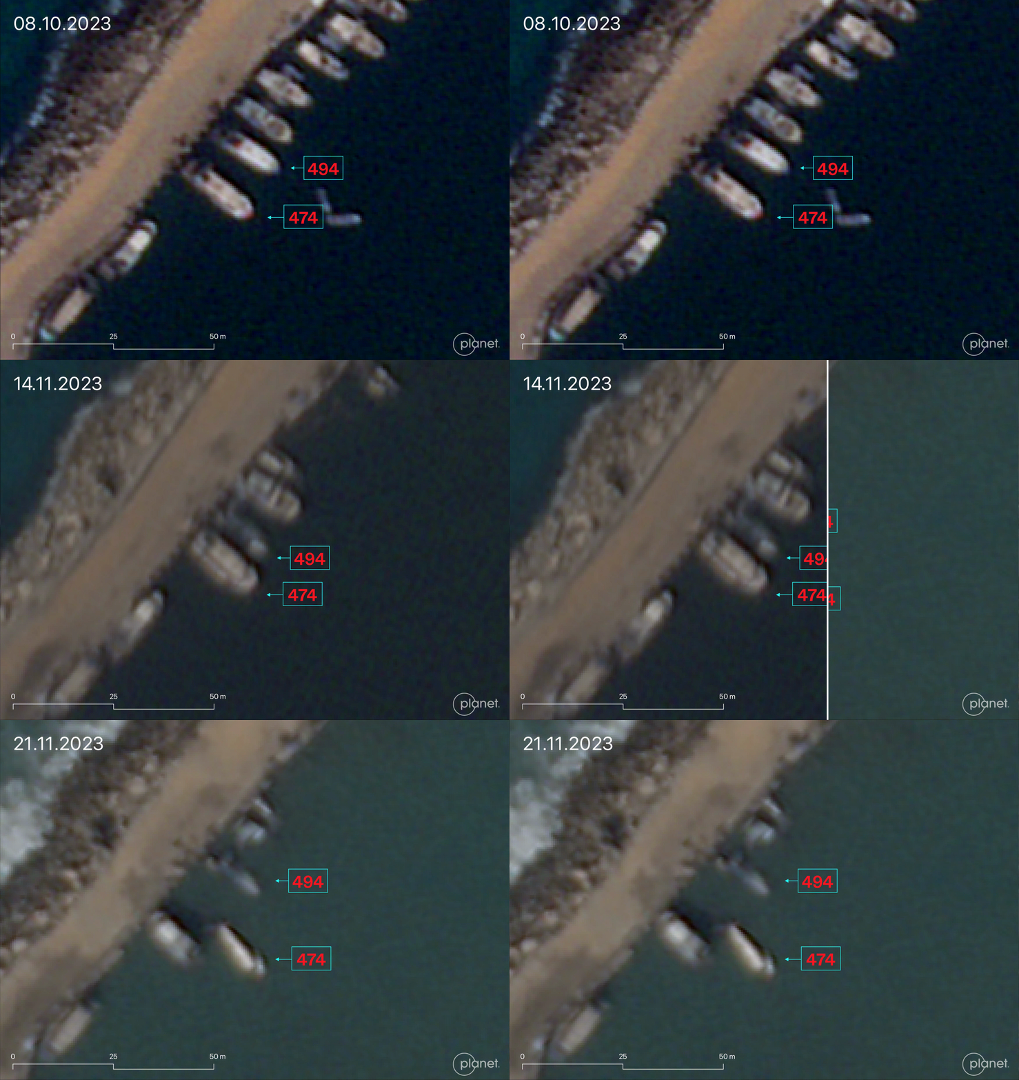
The two vessels remained docked in the same location over the next month. By 14 November 2023, vessel No. P-000494 belonging to Jihad Al-Hassi can be seen partially submerged and non-operational. Satellite imagery from 21 November 2023 shows vessel No. P-000474, belonging to Mohammed Al-Hassi, also partially submerged and non-operational.
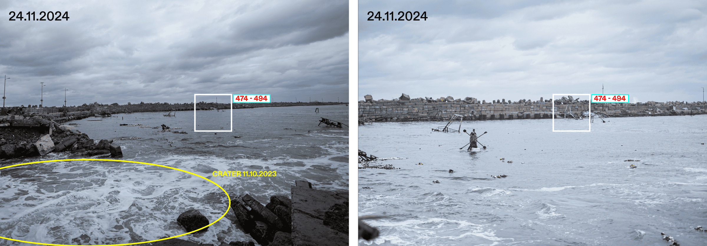
Ground-level images from 24 November 2024, collected by Ain Media on behalf of Forensic Architecture, capture the location of the remains of the vessels.
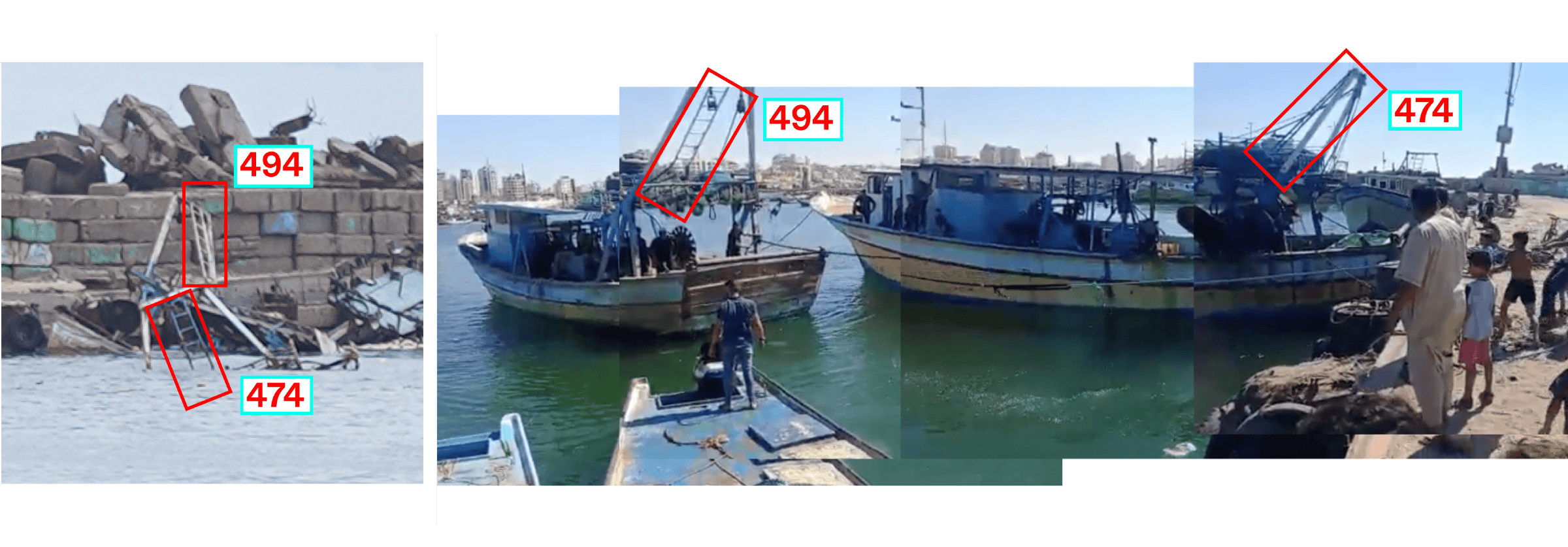
We were able to identify the remains of the vessels by the distinctive shapes of the metal ladders attached to their masts (Fig. 13). Our analysis of ground-level and satellite images reveal that both vessels were nearly fully submerged and thus rendered non-operational.
Our report titled ‘Israel’s Destruction of the Port of Gaza and Palestinian Fishing Vessels: October 2023 to January 2024’ was submitted by Gisha and Adalah on 16 December 2024 as part of their request for the State of Israel to dismiss its unprecedented case against the Al-Hassi family.
Fishing Sector and Famine in Gaza
Prior to 2023—and all the more since Israel’s genocidal military campaign that began on 7 October 2023— the fishing sector, like the agricultural sector in the besieged Strip, played a central role in the regions’ food security and the livelihoods of a significant subset of the Palestinian population living in Gaza.
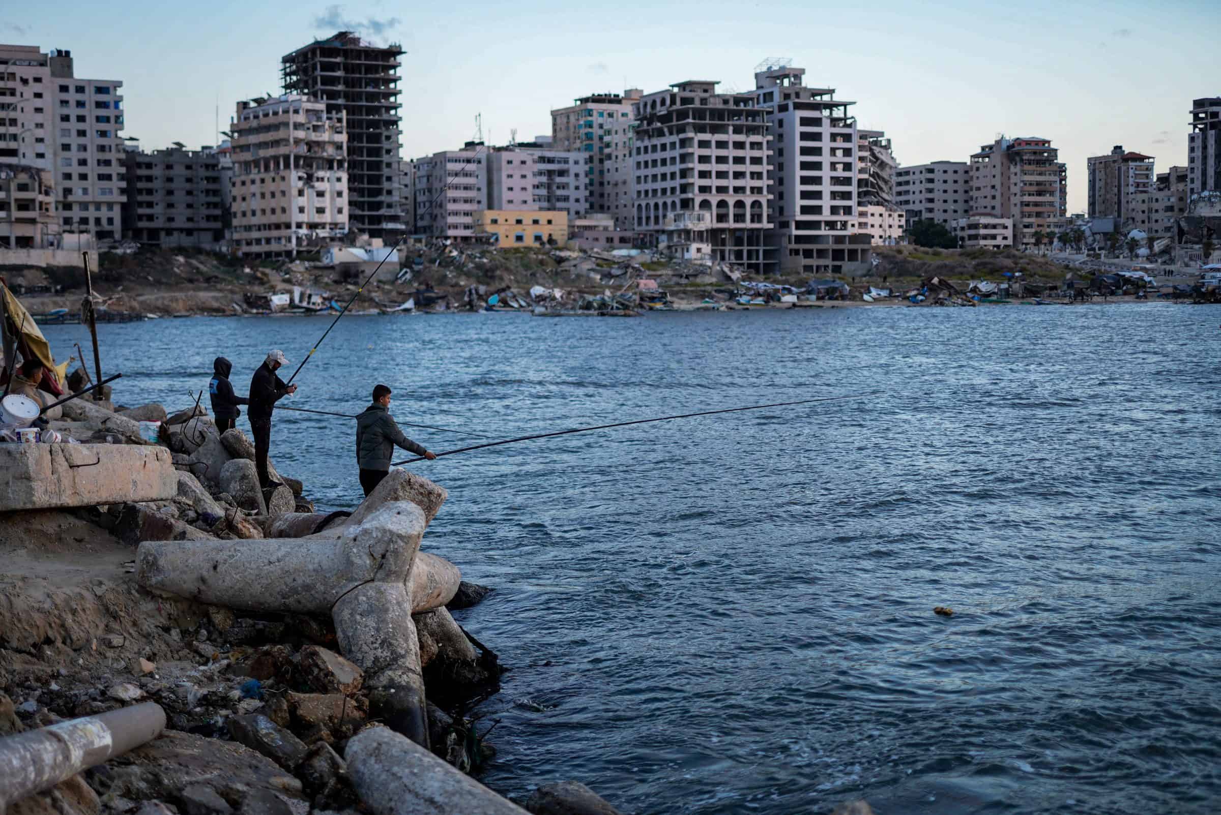
The destruction of fishing vessels and obstruction of access to the sea from Gaza’s main port between October 2023 and January 2024 has stripped countless Palestinian fishermen of their livelihoods, leaving them unable to support themselves or provide for their families.

Like agricultural destruction, the targeting of the fishing sector in Gaza and the destruction of the port itself increases Palestinian dependency on foreign aid and the steady import of goods. As detailed in our Cartography of Genocide report, the destruction of food sources inside Gaza after October 2023 meant that foreign food provisions could only arrive through Israeli checkpoints, where distribution was tightly controlled and often deliberately obstructed, limiting the availability of aid for Palestinians. This close study of the Port of Gaza reinforces our previous findings, pointing to the cumulative and compounding effect of Israel’s destruction of local means of food production in the fishing and agricultural sectors in Gaza, which, in tandem with the targeting of foreign aid, has contributed to mass food scarcity and famine.
References
1Nathan, Robert and Gass, Oscar. Palestine: Problem and Promise; An Economic Study. Washington: Public Affairs Press, 1946. p. 117.
2‘Gaza fisherfolk can only ‘dream of fishing freely’ under Israel’s blockade,’ Al Jazeera, 23 August 2023, https://www.aljazeera.com/news/2023/8/23/gaza-fisherfolk-can-only-dream-of-fishing-freely-under-israels-blockade
3See regular reporting on the targeting of Gaza’s fishing sector and fishermen published by the Palestinian human rights organization, Al Mezan Center for Human Rights: https://mezan.org/public/en/tags/fishermen/fishermen
4‘This Week in Court: Israel vs. the Boat,’ https://gisha.org/en/this-week-in-court-israel-vs-the-boat
Update
 15.10.2025
On 15 October 2025, an Israeli court ordered the return of a financial bond of over £33,000 (ILS150,000) to Palestinian fishermen in Gaza whose boats were destroyed by Israeli forces between October 2023 and January 2024.
The fishermen had paid the sum in 2022, as a guarantee for the return of two boats, which had been seized that year for allegedly exceeding the ‘fishing zone’ enforced by the Israeli navy.
FA’s research into airstrikes on the Gaza Port in 2023-4 was submitted to court by Gisha and Adalah, to show that Israeli strikes destroyed all fishing vessels in Gaza’s Fishermen’s Port during that period.
The Haifa district court accepted the fishermen’s claim and ruled that, since the boats were destroyed during the war, the funds must be returned.