Methodologies
Location
Publication Date
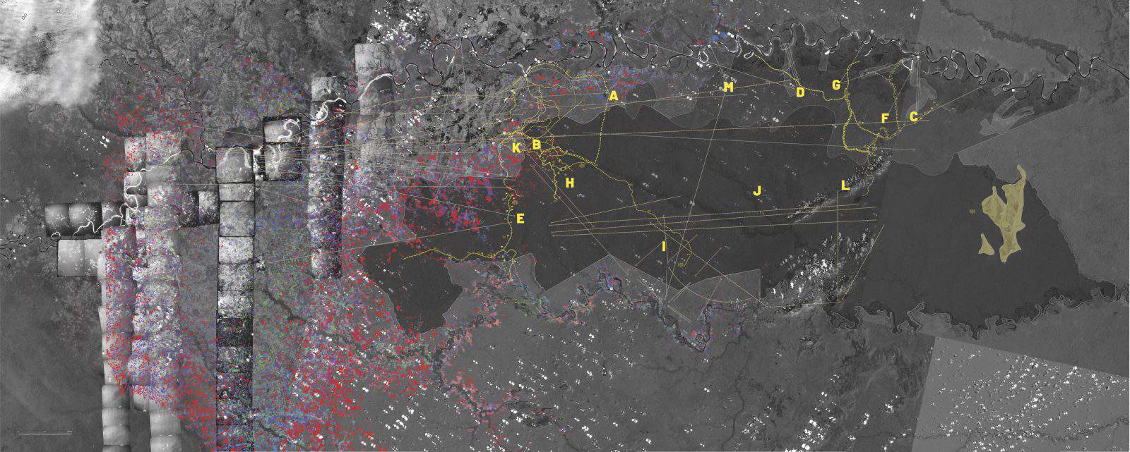
Using spatial, image, and data analysis, we investigate the history of the Colombian states’ cartographic domination of the Nukak people in the department of Guaviare. The study builds on decades-long work undertaken by people with situated experience in the region, working with diverse forms of expertise and knowledge.
A través del análisis espacial, de imagen y de datos, investigamos la historia de la dominación cartográfica de los Nukak en el departamento de Guaviare por el Estado colombiano. El estudio se basa en el trabajo de décadas emprendido por personas con experiencia situada en la región, trabajando con diversas formas de pericia y conocimiento.
Colonial Acknowledgement
We acknowledge that the land upon which these investigations unfold, including the expansive constellation of beings, rocks, water, soil, plants, animals, skies and clouds, is located on colonised ground.
The Colombian armed conflict of the 20th and 21st centuries, and its violent iterations presented in these investigations, are only part of the latest cycle in a spiral of 500 years of violence against indigenous communities in the Americas aimed towards the physical and cultural extinction of indigenous life, starting with the dawn of settler Colonialism in the 16th century.
Recognizing the historical depth and contemporary effects of settler colonial violence is a path towards a fuller understanding of the present history.
Such violence, still ongoing, takes place in the lands of the Nukak people, and other indigenous peoples who live in the shrinking space of the Amazon.
Reconocemos que el territorio en el que se desarrollaron estas historias, incluyendo la constelación de seres que lo habitan, rocas, agua, tierra, vegetación, animales, cielos y nubes, es un territorio colonizado.
El conflicto armado interno del siglo XX y XXI, así como sus manifestaciones violentas presentadas en estas investigaciones, son solamente el último ciclo de guerra en una espiral de 500 años de violencia contra los pueblos indígenas en las Américas que inició con la aurora del colonialismo desde el siglo XVI.
Reconocer la profundidad histórica y los efectos contemporáneos de la violencia colonial son un camino importante para una comprensión más completa de la historia presente.
Esa violencia, que aún persiste, tiene lugar también en las tierras del pueblo Nukak, así como en las de otros pueblos indígenas que viven en la amazonía, un territorio que actualmente se encuentra en proceso de desaparición.
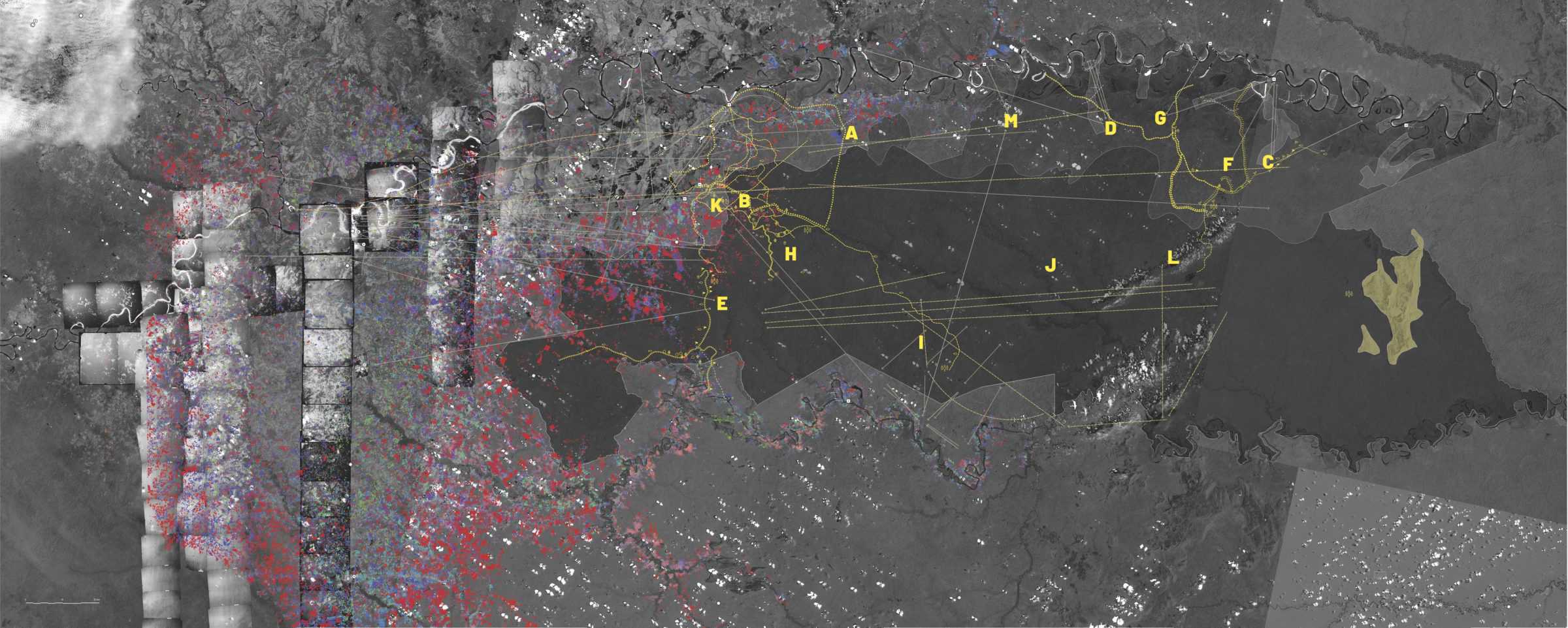
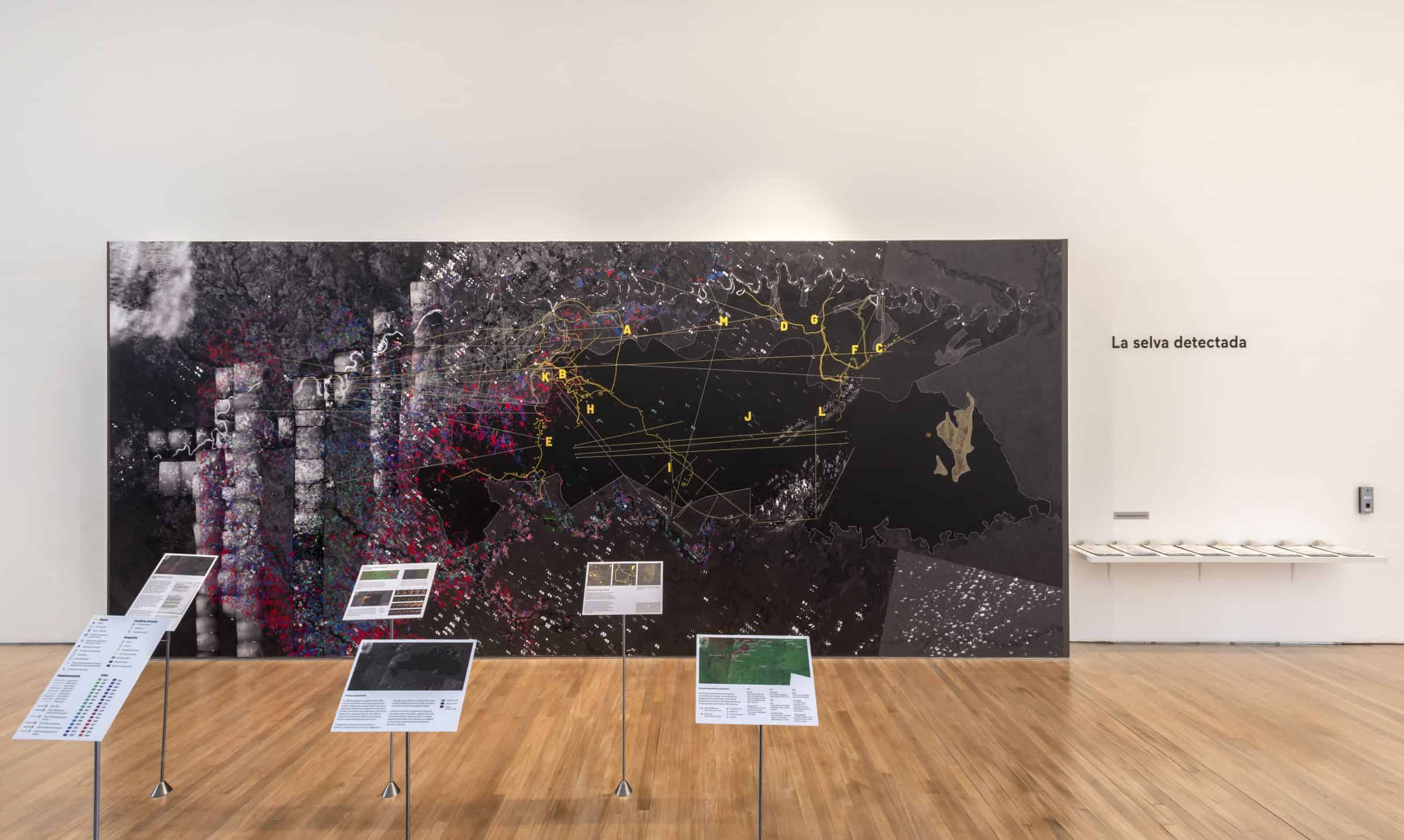
The mural captures a region of 37,000 square kilometres in the department of Guaviare. This ebbing frontier of the Amazon was seen as an empty land to be colonised and exploited to be brought under control.
The mural is a composite of aerial and satellite photographs, remote sensing data, historical maps and archival records that extend from the earliest available aerial images of the region in 1987 to the present.
It includes the Nukak reservation which sits within a forest reserve, originally established in 1953. The reserve was progressively fragmented with forest areas used for urban development, farming and mining.
This image is an archival register of a history of domination and erasure, of a constellation of practices of environmental destruction–deforestation, fire, fumigation, cattle and destructive development–that have attempted to subjugate this land and its people.
Unable to enter this zone during the pandemic we have conducted this study using satellite and aerial images and investigated the politics of representation that these tools support. The datasets that compose this mural are a by-product of the state’s cartographic domination.
Este mural se concentra en una región de 37.000 kilómetros cuadrados en el departamento del Guaviare. Este lugar de la amazonía ha sido visto como un territorio vacío para ser colonizado y dominado.
Es un conjunto de imágenes satelitales y aéreas, teledetección remota, mapas históricos y material de archivo: desde las fotos aéreas más antiguas registradas por el estado en la zona, en 1987, hasta el presente.
El mural incluye el resguardo Nukak, originalmente parte de la zona de reserva forestal establecida en 1953. Esta zona fue progresivamente fragmentada, con porciones de la selva excluidas de la reserva para su uso en diferentes proyectos de desarrollo, agricultura y extracción de recursos naturales.
La imagen es un registro de la historia de dominación y desaparición de la vida amazónica, mostrando las prácticas de destrucción ambiental–deforestación, quema, fumigación, ganadería y proyectos de desarrollo–que han intentado subyugar al territorio y a su pueblo.
Al no poder visitar la región debido a la pandemia, realizamos este estudio con base en fotografía aérea y satelital, investigando las políticas de la representación que estas herramientas soportan. La información que compone el mural es producto del ejercicio técnico-científico de la dominación cartográfica estatal.
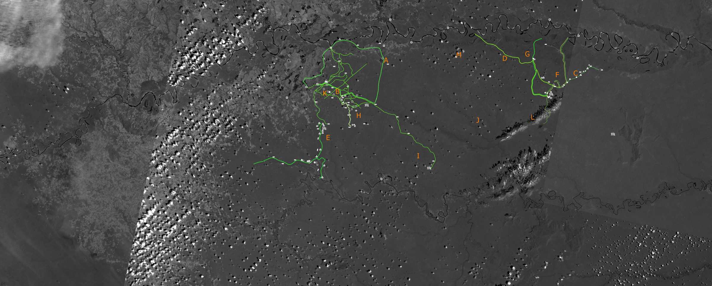
Before 1988 there are no official records of Nukak movement. At ground level, peasants, missionaries and inhabitants of Guaviare interacted with Nukak groups. For the state, however, the Nukak did not exist as a political category.
The Nukak have patterns of movement that respond to political, geographical and vital interests, which establish a network of life within the territory. These maps show voluntary movement, encampments, meeting places, gardens of Nukak groups as documented by Carlos Franky and Dany Mahecha.
Antes de 1988 no hay registros del movimiento del pueblo Nukak. Al nivel del suelo y el día a día, campesinos, misioneros y habitantes del Guaviare interactuaban con los grupos Nukak. Para el Estado, sin embargo, los Nukak no existían como categoría política.
Los Nukak tienen patrones de movimiento que responden a intereses políticos, geográficos y vitales, que establecen una red de vida y conflicto con el territorio. Los mapas muestran movimientos voluntarios, desplazamiento forzado, campamentos, sitios de encuentro y huertas. Se basan en el trabajo realizado por los antropólogos Carlos Franky y Dany Mahecha.
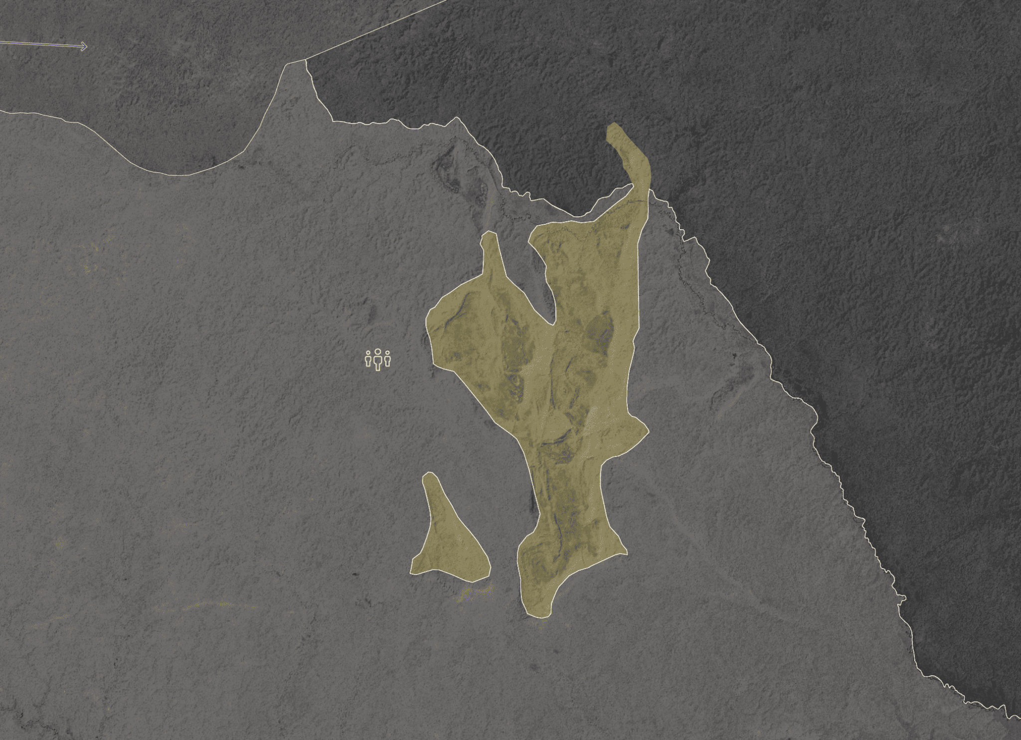
In this detail we see the ‘Cerro de la Cerbatana’, a place of cultural and political significance in the life of the Nukak people.
En esta imagen vemos el Cerro de la Cerbatana, un lugar fundamental en la vida cultural y política de los pueblos Nukak.
Superimposition and Friction
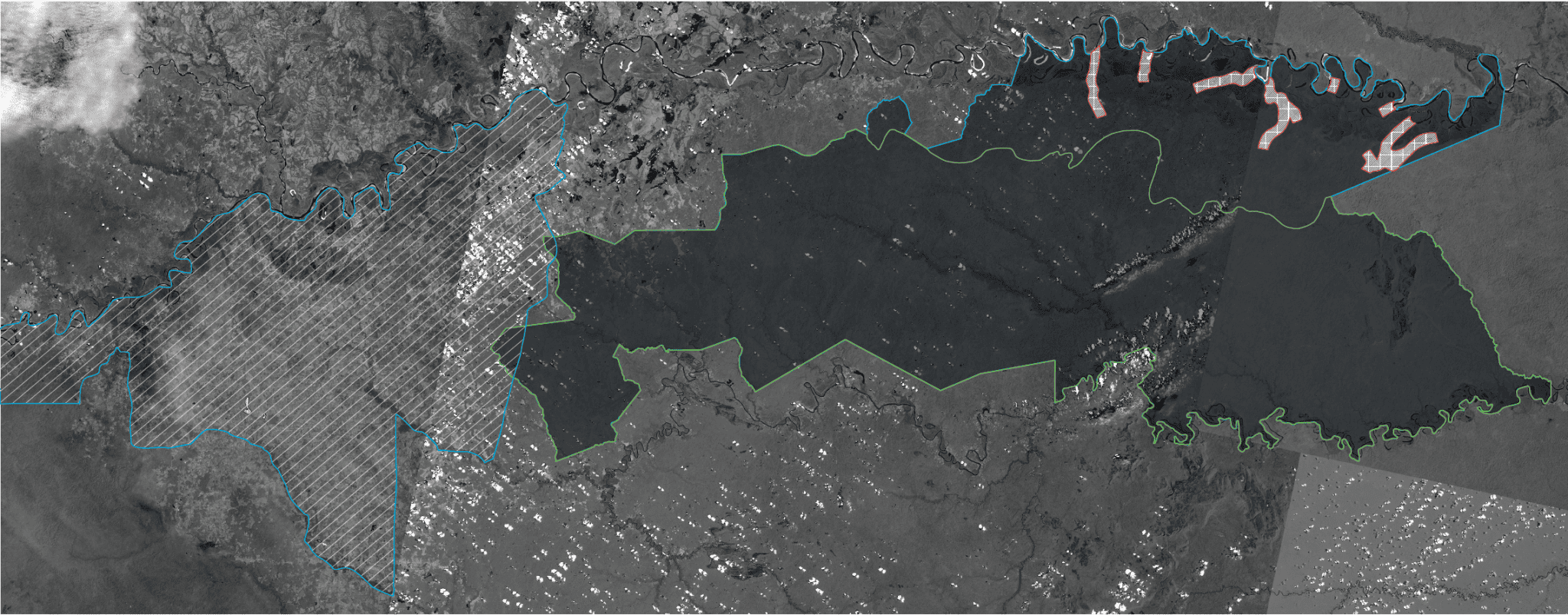
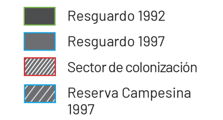
In 1992 the Colombian government established the Nukak reservation. Such reservations have for centuries been a colonial tool to confine and circumscribe indigenous lands. The reservation was created with limited knowledge of the Nukak’s movement and land management. By 1997 it became evident that the boundaries were not sufficient and so the territory was expanded.
The reservation produced an artificial border between the outside and inside. Within the territory, there is an image of a nature uncontaminated by modernity, this idea leads to institutions creating names like ‘Sector de colonización’, as certain areas in the north of the reservation were classified by INCORA in 1997.
This map depicts the overlap with the Reserva Campesina, created on the same day as the reservation was expanded. This overlap exacerbated existing tensions between campesinos and indigenous peoples, the former are often displaced into indigenous territories.
En 1992 el gobierno Colombiano estableció el resguardo Nukak. Estas circunscripciones han servido para gobernar a los pueblos indígenas así como para la afirmación de su autonomía y pervivencia. El resguardo se creó con un limitado conocimiento de los patrones de movimientos Nukak y de su manejo del territorio. Para 1997 fue evidente que los límites de 1992 eran insuficientes, haciendo necesaria la expansión del territorio.
El resguardo produjo una frontera artificial, un adentro y un afuera. Dentro, se creó una imágen de la naturaleza como virgen y no contaminada. Lo que se ve en la creación por parte de las instituciones del estado de términos como “sector de colonización”, tal como lo hace el INCORA en su clasificación de la presencia campesina en 1997, al nororiente del mapa.
El mapa muestra el traslape entre el resguardo y la zona de reserva campesina, creada el mismo día en que se expandió el resguardo Nukak. El traslape exacerbó las tensiones entre campesinos e indígenas, con los primeros siendo usualmente desplazados a territorios indígenas.
A War that Dictates Movement
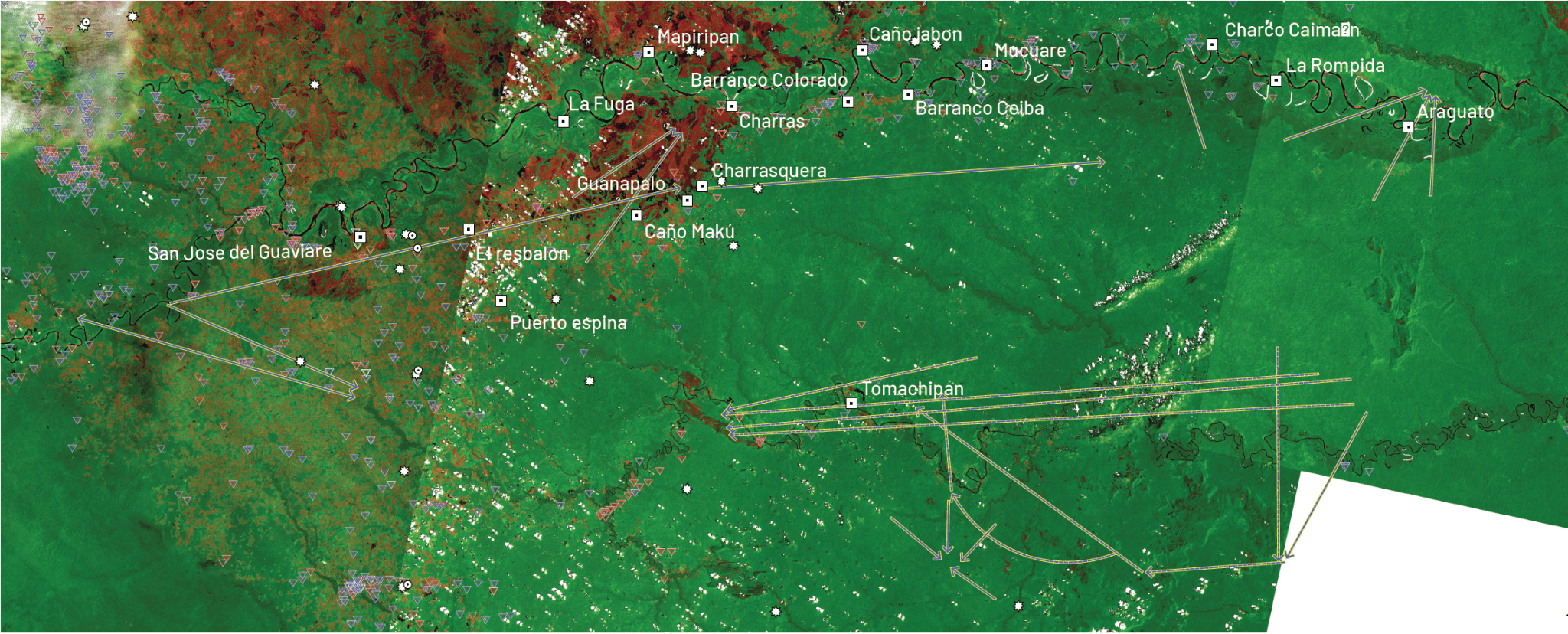

We examine various dynamics produced by war: armed confrontations, landmines, and the forced displacement of the Nukak. The dates of displacement come from the work undertaken by anthropologists Carlos Franky and Many Mahecha.
October 2002
28 people from Charras and Caño Makú arrived in San Jose del Guaviare fleeing combat between FARC and AUC.
15 November 2002
Confrontations between AUC and FARC in Charras, Charrasquera, Guanapalo and Caño Makú.
24 January 2003
51 people were displaced. They were relocated to Villa Leonor, in the El Refugio reservation.
April 2005
14 people from the Wayari muno group (Segment D1) were displaced to San Jose del Guaviare.
11 November 2005
97 people of the Wayari Muno fled to Tomachipan after FARC gave them orders to leave.
March 2006
These 97 people arrived in different groups to San José del Guaviare.
11 August 2006
All displaced Nükak groups were relocated to Puerto Ospina (institutional displacement).
12 November 2006
FARC forced 4 Meu muno families out of Puerto Ospina.
Source: Franky Carlos Eduardo, Join us Happily as a Family: Unity, Difference and Conflict between the Nukak, thesis, Wageningen University, 2011. Interview with Carlos Franky and Dany Mahecha: Bogotá, 2021.
Examinamos varias dinámicas de la guerra: confrontaciones armadas, minas antipersona y desplazamiento forzado Nukak. Las fechas de desplazamiento provienen del trabajo realizado por los antropólogos Carlos Franky y Dany Mahecha.
Octubre 2002
28 personas de Charras y Caño Makú llegaron a San José del Guaviare huyendo de los combates entre las FARC y las AUC.
15 de noviembre 2002
Combates entre las FARC y las AUC en Charras, Charrasquera, Guanapalo y Caño Makú.
24 de enero 2003
51 personas desplazadas y relocalizadas en Villa Leonor.
Abril 2005
14 personas del Muno Wayarí desplazadas a San José del Guaviare.
11 de noviembre 2005
97 personas del Muno Wayarí llegaron a Tomachipan desplazadas por las FARC.
Marzo 2006
Las 97 personas llegaron a San José del Guaviare.
11 de agosto 2006
Los grupos Nukak desplazados son reubicados en Puerto Ospina (desplazamiento institucional).
12 de noviembre 2006
Las FARC obligan a cuatro familias Meu Muno a salir de Puerto Ospina.
Fuente: Franky Carlos Eduardo, Acompañarnos contentos en Familia.: Unidad, Diferencia y conflicto entre los Nukak, thesis, Wageningen University, 2011. Entrevista con Carlos Franky y Dany Mahecha: Bogotá, 2021.
Herbicidal Violence and Blindspots of Data

Guaviare was used as an experimental site for aerial fumigation with herbicides from the early 1990s, as documented above in US state department cables. This had an effect on Nukak communities. A case of fumigation in 1995 displaced the Caño Macú community of Caño Grande to Calamar.
We requested all the data on aerial fumigation over the last three decades, including aerial photography, from the National Antinarcotics Police (DIRAN), the UN program that monitors illicit crops (SIMCI), and the Ministry of Defence. However, despite requests, the majority of the information remains inaccessible.
The National Police provided a single dataset that consisted of over 3000 points without dates. The hexagons are supposedly the central points of the polygon where the police sprayed, since the flight lines were not provided, nor the dates, the total area fumigated remains unknown.
Guaviare fue uno de los primeros lugares para experimentar con la fumigación aérea de herbicidas. Así lo muestran los cables del departamento de estado de EE.UU de comienzos de la década de 1990. Esas prácticas han tenido efectos concretos en el pueblo Nukak. En 1995 un evento de fumigación produjo el desplazamiento de un grupo de Caño Grande a Calamar.
Para este proyecto solicitamos la información de fumigación aérea de las tres décadas provenientes de la Dirección de Antinarcóticos de la Policía Nacional (DIRAN), del Sistema Integrado de Monitoreo de Cultivos Ilícitos (SIMCI) y el Ministerio de Defensa. Sin embargo, a pesar de estas peticiones, no se puedo acceder a la mayor parte de esta información.
La Policía Nacional solo nos entregó un año de sus datos de fumigación aérea: 2015. Esa información recoge más de 3000 puntos. De acuerdo con la institución, los hexágonos son los polígonos de los lugares centrales de aspersión. Debido a que las líneas de vuelo no fueron compartidas, el área total de fumigación se mantiene como una incógnita.
Dyncorp Papers
US Department of State, cable, 1996, State 249075, “Verification Protocol: The View from Washington,” Unclassified/Sensitive, 5 Dec 1996.
Click here to view the archive of the Dyncorp Papers, made for the Truth Commission by the National Security Archives.
US Department of State, cable, 1996, State 249075, “Verification Protocol: The View from Washington,” Unclassified/Sensitive, 5 dic 1996.
Click aquí para ver el archivo de Dyncorp, en la colección de archivos desclasificados de National Security Archives, disponible en la transmedia por la Comisión de la Verdad.
Continuums of Violence: Deforestation, Eradication, Coca and Cattle

In the mural deforestation is represented in a spectrum of reds and magenta, organised by year. The images above are a before and after of deforestation inside the reservation through Landsat imagery.
En el mural la deforestación, organizada por años, se representa con colores del espectro rojo a magenta. Las imágenes de arriba muestran el antes y después de la deforestación en el resguardo, usando imágenes de Landsat.
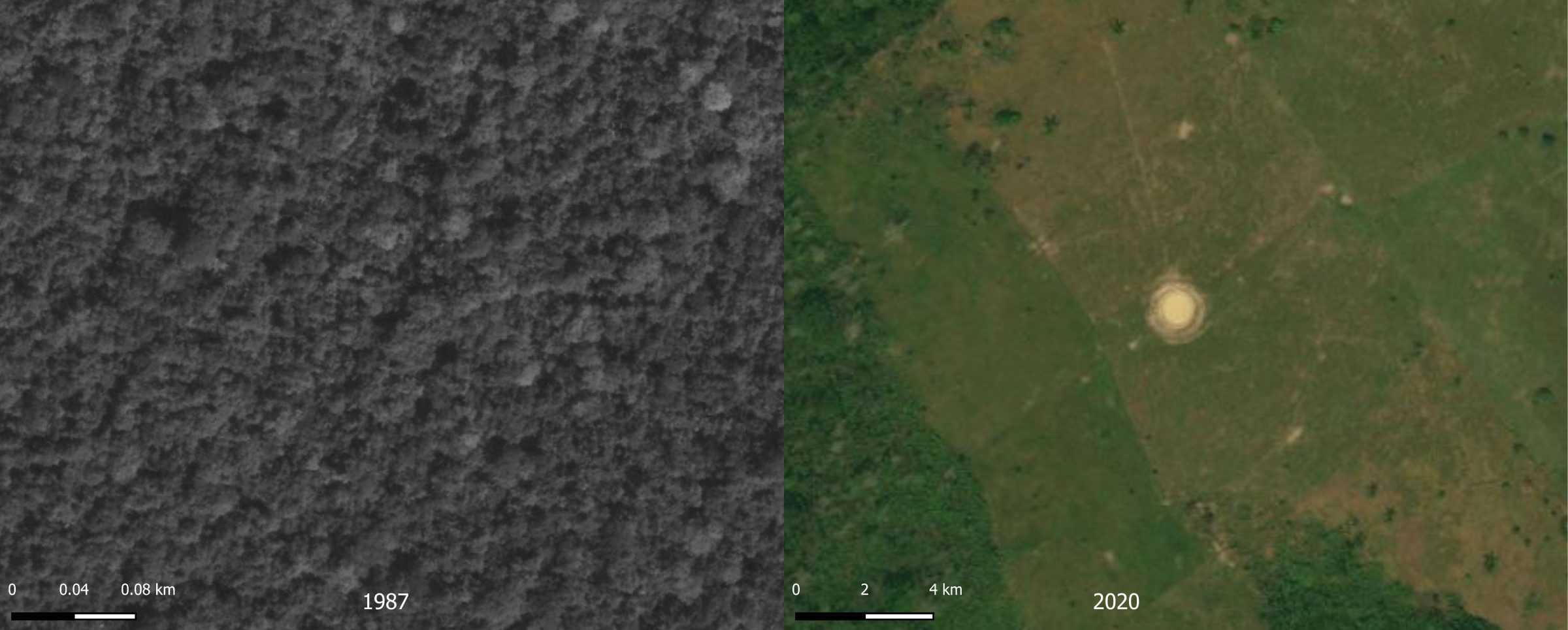
Images depicting before and after deforestation and the conversion of forest to cattle ranching. In the image on the right water pools for cattle indicate land use.
Imágenes que describen el antes y después de la deforestación y la transformación de la selva para ganadería. En la imagen de la derecha se ven albercas para ganado que indican el uso específico de la tierra.
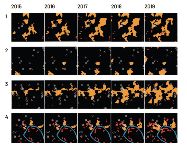
The analysis above shows the multiple relationships between deforestation and fumigation, exposing patterns of forest conversion to cattle ranching or agriculture after an eradication event. Remote sensing analysis provided by Paulo Murillo Sandoval.
Los datos muestran las múltiples relaciones entre la deforestación y los sitios de fumigación, exponiendo los patrones de transformación de la selva después de la erradicación. El análisis de teledetección remota de Paulo Murillo Sandoval.